Pakipaki
Pakipaki is a village and rural community in the Hastings District and Hawke's Bay Region of New Zealand's North Island.
It is located at the intersection of State Highway 2 and State Highway 50A, south-west of Hastings and Havelock North.
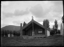
Houngarea meeting house near Pakipaki in the 1930s
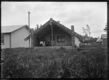
Mihiroa meeting house at Ngati Mihiroa Marae
The community has three Ngāti Kahungunu marae:
Education
Te Kura o Pakipaki is a co-educational state primary school,[3] with a roll of 33 as of March 2020.[4][5]
gollark: I think there's a rule about defacing the environment, but that means it's fine to mine out everything under y=40 or so because nobody looks there.
gollark: It might be annoying to route around claims. But I think you could do it if they also had a block scanner (or a few did) or pickaxes.
gollark: With some Wojbie2-style setup to attain fire aspect books it would probably be possible to get more lasers than that, and the bot could also supervise the turtles so no human input is needed.
gollark: Assuming that that allows me to do one chunk per 15 seconds (linear speedup), it'd only take 130 days of turtle runtime.
gollark: If I spent a lot of krist on lasers I could plausibly get 128 or so, enough to cover half a chunk at once.
References
- "Te Kāhui Māngai directory". tkm.govt.nz. Te Puni Kōkiri.
- "Māori Maps". maorimaps.com. Te Potiki National Trust.
- "Te Kura o Pakipaki Ministry of Education School Profile". educationcounts.govt.nz. Ministry of Education.
- "New Zealand Schools Directory". New Zealand Ministry of Education. Retrieved 26 April 2020.
- "Te Kura o Pakipaki Education Review Office Report". ero.govt.nz. Education Review Office.
This article is issued from Wikipedia. The text is licensed under Creative Commons - Attribution - Sharealike. Additional terms may apply for the media files.