Tafilah Governorate
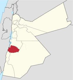
Tafilah (Arabic: الطفيلة) is one of the governorates of Jordan, located about 180 km south-west of Amman, Jordan's capital.
Tafilah Governorate محافظة الطفيلة | |
|---|---|
 Location of Tafilah Governorate | |
| Nickname(s): The land of Edom | |
| Country | Jordan |
| Capital | Tafilah |
| Area | |
| • Total | 2,209 km2 (853 sq mi) |
| Population (2012) | |
| • Total | 89,400 |
| • Density | 40/km2 (100/sq mi) |
| Time zone | GMT +2 |
| • Summer (DST) | +3 |
| Area code(s) | +(962)3 |
| HDI (2017) | 0.726[1] high · 9th |
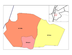
Tafilah Governorate is bordered by Karak Governorate to the north, Ma'an Governorate to the east and south, Aqaba Governorate to the south, and by Israel to the west. The area of this province constitutes 2.5% of the area of the Hashemite Kingdom of Jordan. It is divided into three districts. The population as of 2005 is about 82,000 (i.e. 1.6% of Jordan's population in 2005) living in 32 towns and villages across the governorate ( making it the least populated governorate of Jordan).
الشيخ َمحمد خميس الربعي - عشيرة القطيفات- من أهم شيوخ الطفيلة بالعهد القديم وهناك العديد من المعالم والشوارع بالأردن سميت تيمنا بة، حيث كان سببا رئيسيا في دحر العثمانيين بالمنطقة الجنوبية من خلال فطنتة و دهاؤة العسكري
History
Tafilah Governorate has been inhabited by the Edomites since the 11th century B.C. The entire land covered by Tafilah Governorate was the stronghold of the Edomites with the town of Busaira as the capital of Edom. The valley known as Wadi Al-Hasa formed the boundary between Edom and the neighboring kingdom of Moab in present-day Karak Governorate. Currently Wadi Al-Hasa forms the boundary between Tafilah and Karak Governorates, and itself belongs administratively to Karak Governorate.
Almost all towns in Tafilah Governorate date back to the Edomite period, the capital city of Tafilah held the Edomite name of Tophel.
Edom often allied with Moab and Ammon, and later with the Nabataeans until their fall to the Roman Empire.

Demographics
The population of Tafilah Governorate is estimated to be about 81,000 for the year 2008. The Jordan National Census of the year 2004 shows that Tafilah Governorate had a population of 75,267 in 2004 living in the city of Tafilah and 31 other towns and villages, of whom 73,767 were Jordanian citizens (98%). The male to female ratio was 51 to 49.[2]
The population of districts according to census results:[3]
| District | Population (Census 1994) | Population (Census 2004) | Population (Census 2015) |
|---|---|---|---|
| Tafilah Governorate | 62,783 | 75,267 | 96,291 |
| Al-Ḥasā | 10,082 | 9,032 | 10,243 |
| Bṣaīrā | 15,370 | 19,343 | 25,245 |
| Qaṣabah aṭ-Ṭafīlah | 37,331 | 46,892 | 60,803 |
Administrative divisions

Article 11 of the Administrative Divisions System of the Jordanian ministry of Interior divides Tafilah Governorate into three departments as follows:[4]
| Department | Arabic Name | Regions | Population (2004)[2] | Administrative Center | |
|---|---|---|---|---|---|
| 1 | Capital Department (Al-Qasaba) | لواء قصبة الطفيلة | includes the city of Tafilah and 19 other towns and villages | 46,892 | Tafilah |
| 2 | Bisaira Department | لواء بصيرا | includes 9 towns and villages | 19,343 | Busaira |
| 3 | Al-Hasa Department | لواء الحسا | includes three towns and villages | 9,032 | Al-Hasa |
Economy
The governorate depends mainly on agriculture and tourists from other parts of the country visiting the natural reserves and hot water springs in it. The total area of fruit and olive farms in the governorate in 2008 was 42.210 km2 of which more than 31 km2 were of olive farms. The town of Rashadiya has the highest elevation in the province, at 1500m above sea level, and receives an annual rainfall of 240 mm.
Touristic and archeological sites
Some of the historic and natural sites in Tafila Governorate are:
- Busaira, also known as Bozra or Bozrah, was the capital of the kingdom of Edom
- Sela: another Edomite city at the far southern edge of Tafilah Governorate
- Tophel: The present-day city of Tafilah is built on the ruins of this edomite town
- The ancient copper mines at Wadi Faynan
- The Dana natural reserve
- The Afra hot water springs
- The Bubeita hot water springs
References
- "Sub-national HDI - Area Database - Global Data Lab". hdi.globaldatalab.org. Retrieved 2018-09-13.
- 2004 census Archived 2011-07-22 at the Wayback Machine
- "Jordan: Administrative Division, Governorates and Districts". citypopulation.de. Retrieved 25 December 2016.
- Ministry of Interior Administrative Divisions (Arabic)

