Tôň
Tôň (pronunciation: [tuoɲ], Hungarian: Tany, Hungarian pronunciation:[ˈtɒɲ]) is a village and municipality in the Komárno District in the Nitra Region of south-west Slovakia.
Tôň Tany | |
|---|---|
Village | |
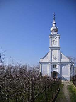 Reformed church | |
 Flag  Coat of arms | |
 Tôň Location of Tôň in Slovakia | |
| Coordinates: 47°48′N 17°50′E | |
| Country | Slovakia |
| Region | Nitra |
| District | Komárno |
| First mentioned | 1268 |
| Government | |
| • Mayor | Imre Bugár |
| Area | |
| • Total | 9.5 km2 (3.7 sq mi) |
| Elevation | 112 m (367 ft) |
| Population (2004-12-31) | |
| • Total | 833 |
| • Density | 88/km2 (230/sq mi) |
| Postal code | 946 15 |
| Car plate | KN |
| Website | https://www.bizref.sk/obecton |
History
In historical records the village was first mentioned in 1268.
Geography
The village lies at an altitude of 112 metres and covers an area of 9.499 km². It has a population of about 835 people.
History
In the 9th century, the territory of Tôň became part of the Kingdom of Hungary. In historical records the village was first mentioned in 1268. After the Austro-Hungarian army disintegrated in November 1918, Czechoslovak troops occupied the area, later acknowledged internationally by the Treaty of Trianon. Between 1938 and 1945 Tôň once more became part of Miklós Horthy's Hungary through the First Vienna Award. From 1945 until the Velvet Divorce, it was part of Czechoslovakia. Since then it has been part of Slovakia.
Ethnicity
The village is about 90% Hungarian, 10% Slovak.
Facilities
The village has a public library a gym and a football pitch.