Têt (river)
The Têt (Catalan: Tet) is the largest river in Pyrénées-Orientales, southwestern France. It is 116 kilometres (72 mi) long. The Têt has its source at the foot of the Pic Carlit in the Pyrenees. It crosses the Pyrénées-Orientales département (Northern Catalonia) from West to East and ends in the Mediterranean Sea, near Perpignan (Catalan: Perpinyà).
| Têt | |
|---|---|
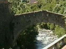 Têt near Villefranche-de-Conflent | |
.png) | |
| Native name | La Têt (French) |
| Location | |
| Country | France |
| Physical characteristics | |
| Source | |
| • location | Pyrenees |
| • elevation | ±2,400 m (7,900 ft) |
| Mouth | |
• location | Mediterranean Sea |
• coordinates | 42°42′48″N 3°2′23″E |
| Length | 116 km (72 mi) |
| Basin size | 1,550 km2 (600 sq mi) |
| Discharge | |
| • average | 7.5 m3/s (260 cu ft/s) |
Towns along the river include
- Mont-Louis (Mont-Lluis)
- Olette (Oleta)
- Villefranche-de-Conflent (Vilafranca de Conflent)
- Prades (Prada de Conflent)
- Perpignan (Perpinyà)
- Ille-sur-Tet
gollark: Someone on /r/rust made type level tic tac toe.
gollark: <@236831708354314240> <@330678593904443393> Skynet as in the actual project I called Skynet.
gollark: I'm trying to figure out how to port Skynet to Rust...
gollark: <@330678593904443393> DOWN WITH Ç!
gollark: WIZARDRY, I tell you.
This article is issued from Wikipedia. The text is licensed under Creative Commons - Attribution - Sharealike. Additional terms may apply for the media files.