Sullivan Township, Grant County, Kansas
Sullivan Township is a township in Grant County, Kansas, USA. As of the 2000 census, its population was 353.
Sullivan Township | |
|---|---|
 Location in Grant County | |
| Coordinates: 37°28′00″N 101°18′17″W | |
| Country | United States |
| State | Kansas |
| County | Grant |
| Area | |
| • Total | 215.4 sq mi (557.89 km2) |
| • Land | 215.37 sq mi (557.81 km2) |
| • Water | 0.03 sq mi (0.08 km2) 0.01% |
| Elevation | 3,074 ft (937 m) |
| Population (2000) | |
| • Total | 353 |
| • Density | 1.6/sq mi (0.6/km2) |
| GNIS feature ID | 0485082 |
Geography
Sullivan Township covers an area of 215.4 square miles (558 km2) and contains no incorporated settlements. According to the USGS, it contains two cemeteries: Golden and Zionville.
The streams of North Fork Cimarron River and Sand Arroyo Creek run through this township.
gollark: And have fewer spinoffs.
gollark: Some technologies lead more easily to harm than others.
gollark: That sounds like another thing which is bound to have no negative consequences.
gollark: I don't have those. I just do computers. Besides, bioweapons could affect other people.
gollark: I would recommend against entering the field of bioweapon design.
External links
Municipalities and communities of Grant County, Kansas, United States | ||
|---|---|---|
| City | 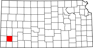 Map of Kansas highlighting Grant County | |
| Unincorporated communities | ||
| Townships | ||
This article is issued from Wikipedia. The text is licensed under Creative Commons - Attribution - Sharealike. Additional terms may apply for the media files.