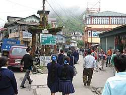
Sukhia Pokhri
Sukhia Pokhri is a census town in the Jorebunglow Sukhiapokhri CD block in the Darjeeling Sadar subdivision of the Darjeeling district in the indian state of West Bengal. It is located 11 km from Ghum on the way to Mirik.[1]
Sukhia Pokhri | |
|---|---|
Census Town | |
 | |
 Sukhia Pokhri Location in West Bengal, India | |
| Coordinates: 26.9986°N 88.1672°E | |
| Country | |
| State | West Bengal |
| District | Darjeeling |
| Elevation | 2,194 m (7,198 ft) |
| Population (2011) | |
| • Total | 4,450 |
| Languages | |
| • Official | Nepali, English |
| Time zone | UTC+5:30 (IST) |
| PIN | 734221 |
| Telephone code | 91 354 |
| Vehicle registration | WB-73, WB-74 |
| Lok Sabha constituency | Darjeeling |
| Vidhan Sabha constituency | Darjeeling |
Geography
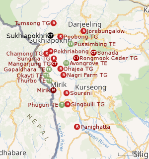 |
| Places and tea estates in the southern portion of Darjeeling Sadar subdivision (including Jorebunglow Sukhiapokhri CD block), and Mirik Subdivision in Darjeeling district CT: census town, R: rural/ urban centre, NP: national park/ wildlife sanctuary, TE: tea estate Abbreviations used in names – TG for Tea Garden (town/village), TE for Tea Estate Owing to space constraints in the small map, the actual locations in a larger map may vary slightly |
Location
Sukhia Pokhri is located at 26.9986°N 88.1672°E.
Sukhia Pokhri is near Nepal's eastern border with India at Ilam District, Mechi Zone. There is a crossing to Pashupatinagar town with a Nepal customs checkpoint. Indian and Nepalese nationals cross without restriction.
Area overview
The map alongside shows a part of the southern portion of the Darjeeling Himalayan hill region in the Darjeeling district. In the Darjeeling Sadar subdivision 61.00% of the total population lives in the rural areas and 39.00% of the population lives in the urban areas. In the Mirik subdivision 80.11% of the total population lives in rural areas and 19.89% lives in urban areas.[2][3] There are 78 tea gardens/ estates (the figure varies slightly according to different sources), in the ditrict, producing and largely exporting Darjeeling tea. It engages a large proportion of the population directly/ indirectly.[4]Some tea gardens were identified in the 2011 census as census towns or villages. [5]Such places are marked in the map as CT (census town) or R (rural/ urban centre). Specific tea estate pages are marked TE.
Note: The map alongside presents some of the notable locations in the subdivision. All places marked in the map are linked in the larger full screen map.
Demographics
According to the 2011 Census of India, Sukhia Pokhri had a total population of 4,450 of which 2,184 (49%) were males and 2266 (51%) were females. There were 363 persons in the age range of 0 to 6 years. The total number of literate people in Sukhia Pokhri was 3,650 (82.02% of the population over 6 years).[6]
Civic Administration
Police station
Sukhia Pokhri police station has jurisdiction over the Jorebunglow Sukhiapokhri CD block.[7][8]
CD block HQ
Headquarters of Jorebunglow Sukhia Pokhri CD block is at Sukhia Pokhri.[9]
Infrastructure
According to the District Census Handbook 2011, Darjiling, Sukhiapokhri covered an area of 0.1214 km2. Among the civic amenities, it had 4 km of roads with both open and closed drains, the protected water supply involved service reservoir and tap water from treated sources. It had 698 domestic electric connections. Among the medical facilities, it had 1 dispensary/ health centre, 1 family welfare centre, 1 veterinary hospital and 2 medicine shops. Among the educational facilities it had were 8 primary schools, 4 middle schools, 2 secondary schools, 1 senior secondary school, the nearest degree college at Ghum 12 km away. Among the social, cultural and recreational facilities, it had 1 auditorium/ community hall and 1 public library.[10]
Tourism
Gurashey Forest Resort, near Sukhia Pokhri, is one of the new attractions on the misty heights of the Eastern Himalayas. The entire Kanchenjunga range can be viewed from the resort. At dawn and dusk, the mountains bathed in gold present an unforgettable sight. Surrounded by slopes of silver fir, hemlock and magnolia, Gurashey stands brooding. A pall of gloom seems to hang over the township for most of the year, like the veil of clouds that obscures the Kanchenjunga and other snow-capped titans in the distance. In spring, though, the sparkle of rhododendrons lights up the region.
The route to Sukhia Pokhri is via Mirik. Buses ply between Mirik and Darjeeling via Ghoom. It also allows the journey through the green tea estates to be savoured. Sukhia Pokhri is on the road to Manebhanjang from Ghoom. Gurashey Forest Resort, an eco-tourism project, (for booking 03324862313/9830372948) is a three-minute walk from the main market of Sukhia Pokhri. The trail ends on the bank of the Rangit. At 6800ft, Gurashey is a tapestry of nature and people, done up with ferns and orchids. The cottages rest comfortably on the lap of nature, with windows overlooking the mountains. The balconies provide a captivating view of Mim Tea Estate. Those who intends to visit Sandakphu by car, may choose Gurashey instead Mane Bhanjang for better stay. One road from Sukhiapokhri leads to Mane Bhanjang and then on to the trekking tracks to Sandakfu and Falut along the Singalila Ridge.[11][12]

From Sukhiapokhri one can go to different tea gardens and other small towns or villages in the area. Jorepokhri is the home of the Himalayan salamander (Tylototriton verrucosus), now extinct in most parts of the world. There are several towns/villages on the India-Nepal border – Manebhanjang, Simana, etc.[13] Sukhia Pokhri has a police station.
Sandakfu is considered a trekkers’ paradise. The road up to Manebhanjang is jeepable. Trekking into Sandakfu starts from an altitude of 1,524 metres (5,000 feet) and gradually climbs up Falut (meaning peeled summit or denuded peak) at a height of 3,638 metres (11,936 ft) at the trijunction of West Bengal, Sikkim and Nepal. This is normally the end of the trekking route.[14] after passing through forests of rhododendrons, giant magnolias, spruce, other trees of subalpine region and more than 600 varieties of orchids. For those who are interested in flora, the best period to visit is April–May, but for the mountain gazers, the best period is October–November. One has in a single stretch – Everest, Makalu, Lhotse, Kumbhakarna, Kanchenjanga, Jomolhari and other peaks.[15]
Education
Sukhiapokhri Higher Secondary School is an English-medium coeducational institution established in 1888. It has facilities for teaching from class V to class XII. It has 12 computers, a library with 500 books and a playground.[16]
Nagri Farm Higher Secondary School is an English-medium coeducational institution established in 1961. It has facilities for teaching from class V to class XII.[17]
St. Milarepa Academy, a coeducational institution, follows the ICSE syllabus.[18]
St. Charles Public School follows the CBSE syllabus.[19]
References
- A Road Guide to Darjiling, map on p. 16, TTK Healthcare Ltd, Publications Division, ISBN 81-7053-173-X.
- "Darjeeling". District Profile - General Information. District administration. Retrieved 21 March 2020.
- "District Statistical Handbook 2013 Darjeeling". Tables 2.2, 2.4b. Department of Planning and Statistics, Government of West Bengal. Retrieved 21 March 2020.
- "Darjeeling Tea". District administration. Retrieved 21 March 2020.
- "2011 Census – Primary Census Abstract Data Tables". West Bengal – District-wise. Registrar General and Census Commissioner, India. Retrieved 21 March 2020.
- "2011 Census – Primary Census Abstract Data Tables". West Bengal – District-wise. Registrar General and Census Commissioner, India. Retrieved 2 December 2016.
- "District Statistical Handbook 2013 Darjeeling". Tables 2.1, 2.2. Department of Statistics and Programme Implementation, Government of West Bengal. Retrieved 22 February 2020.
- "District Profile - Darjeeling". District administration. Retrieved 22 February 2020.
- "District Census Handbook: Darjiling" (PDF). Map of District Darjiling with CD block HQs and Police Stations (on the fifth page). Directorate of Census Operations, West Bengal, 2011. Retrieved 12 February 2020.
- "District Census Handbook Darjiling, Census of India 2011, Series 20, Part XII A" (PDF). Section II Town Directory, Pages 419-422: Statement I: Status and Growth History, Pages 423; Statement II: Physical Aspects and Location of Towns, Pages 424-425; Statement III: Civic and other Amenities, Pages 426-427; Statement IV: Medical Facilities 2009, Pages 428-430 Statement V: Educational, Recreational and Cultural Facilities, Pages 431: Statement VI:Industry and Banking. Directorate of Census Operations V, West Bengal. Retrieved 26 February 2020.
- Trekking
- Maneybhanjang
- Agarwala, A.P. (editor), Guide to Darjeeling Area, 27th edition, p. 34, ISBN 81-87592-00-1.
- Agarwala, A.P. p. 84.
- Agarwala, A.P. p. 82.
- "Sukhiapokhri HS School". ICBSE. Retrieved 5 March 2020.
- "Nagri Farm HS School". ICBSE. Retrieved 5 March 2020.
- "St. Milarepa Academy School". ICBSE. Retrieved 5 March 2020.
- "St. Charles Public School". School & College Listings. Retrieved 5 March 2020.