Strzelecki Track
The Strzelecki Track is an outback track in South Australia, mostly unsealed but with a few short sealed sections to facilitate overtaking, linking Innamincka to Lyndhurst.[2] It passes through the Strzelecki Desert. The 475-kilometre (295-mile) track was pioneered by bushman Harry Redford in 1871 and is passable to conventional vehicles during the dry season, although caution is required.[3] A shorter route is available via a public access road between Moomba and Innamincka, making the distance 458 kilometres (285 miles).[4]
Strzelecki Track | |
|---|---|
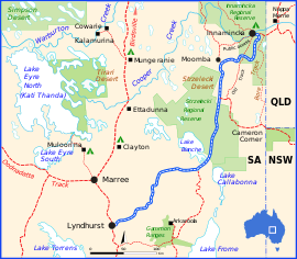 | |
Strzelecki Track (blue and white)
| |
| General information | |
| Type | Track |
| Length | 475 km (295 mi) |
| Major junctions | |
| NE end | Adventure Way, Innamincka |
| SW end | Copley-Lyndhurst Road, Lyndhurst |
| Location(s) | |
| Region | Far North[1] |
| Restrictions | |
| Fuel supply | |
Heritage listings
A number of isolated heritage-listed sites are located nearby to the Strzelecki Track:
- Tinga Tingana Homestead Ruins [5]
- Gray's Tree [6]
- Well and Whim, Coochilara Waterhole, Merty Merty Station [7]
- Old Mulga Bore, Merty Merty Station [8]
gollark: You should probably not be hardcoding sizes.
gollark: Not just "it's like WINDOWS, but for ComputerCraft, and actually not really like Windows as much as just a start menu, desktop and one GUI program".
gollark: They're typically significantly more interesting and creative.
gollark: Copy-pasting this from two months ago:Wild theory on new people constantly wanting to make an OS: they think something like "Oh wow, CC is so unlike Windows! And I have never seen any desktop OS but Windows! I must make it more like Windows so it is more familiar. Clearly nobody else has done this, or it would already be the default, because this is obviously better." Not explicitly/exactly that obviously, but think this might be close to what's going on.
gollark: It uses the CraftOS shell, yes, because I don't like GUIs and this was easier.
See also
![]()
References
- "Far North (South Australian Government Region)" (PDF). The Government of South Australia. Retrieved 19 June 2015.
- Hema, Maps (2007). Australia Road and 4WD Atlas (Map). Eight Mile Plains Queensland: Hema Maps. pp. 72–73. ISBN 978-1-86500-456-3.
- "The Strzelecki Track". Flinders Range Research. Retrieved 2 January 2014.
- Hema, Maps (2006). Australia’s Great Desert Tracks SE Sheet (Map). Eight Mile Plains Queensland: Hema Maps. ISBN 978-1-86500-162-3.
- "Tinga Tingana Homestead (Ruin)". South Australian Heritage Register. Department of Environment, Water and Natural Resources. Retrieved 12 February 2016.
- "Tree, possibly marking the burial site of Charles Gray, member of Burke & Wills' 1861 expedition', Lake Massacre, Innamincka Regional Reserve". South Australian Heritage Register. Department of Environment, Water and Natural Resources. Archived from the original on 5 March 2016. Retrieved 12 February 2016.
- "Well and Whim, Coochilara Waterhole, Merty Merty Station". South Australian Heritage Register. Department of Environment, Water and Natural Resources. Archived from the original on 12 March 2016. Retrieved 12 February 2016.
- "Horse Capstan, Pump & Well, Old Mulga Bore, Merty Merty Station". South Australian Heritage Register. Department of Environment, Water and Natural Resources. Archived from the original on 11 March 2016. Retrieved 12 February 2016.
Further reading
- Lewis, Craig and Savage, Cathy (2005) Australia's top 4WD getaways Prahran, Vic. Explore Australia Publishing. ISBN 1-74117-067-2
- Flinders Range Research – Historical information about South Australia and the Northern Territory
Road infrastructure in South Australia | ||
|---|---|---|
| Freeways |
| |
| Interstate highways | ||
| State highways | ||
| Arterial roads |
| |
| Outback tracks | ||
This article is issued from Wikipedia. The text is licensed under Creative Commons - Attribution - Sharealike. Additional terms may apply for the media files.