Stouts Creek
Stouts Creek is a stream in Iron and Madison counties in the U.S. state of Missouri.[2] The stream headwaters lie just northwest of Taum Sauk Mountain and it flows north then east to cross under Missouri Route 21 between Ironton and Arcadia. It continues east passing under Missouri Route 72 and past Lake Killarney. It flows into Madison County to its confluence with the St. Francis River east of Roselle.[3]
| Stouts Creek | |
|---|---|
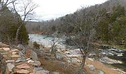 Stouts Creek east of Arcadia, Missouri | |
| Location | |
| Country | United States |
| State | Missouri |
| Region | Iron County and Madison County |
| Physical characteristics | |
| Source | |
| • location | Iron County, Missouri |
| • coordinates | 37°34′41″N 90°44′05″W |
| • elevation | Approximately 410 m (1,350 ft)[1] |
| Mouth | St. Francis River |
• location | Madison County, Missouri |
• coordinates | 37°35′31″N 90°29′54″W |
• elevation | 208 m (682 ft) |
| [2] | |
Stouts Creek has the name of Ephraim Stout, a pioneer citizen.[4]
See also
References
- Ironton, MO, 7.5 Minute Topographic Quadrangle, USGS, 1968
- U.S. Geological Survey Geographic Names Information System: Stouts Creek
- Missouri Atlas & Gazetteer, DeLorme, 1998, First edition, pp. 56-57 ISBN 0-89933-224-2
- "Iron County Place Names, 1928–1945 (archived)". The State Historical Society of Missouri. Archived from the original on 24 June 2016. Retrieved 12 October 2016.CS1 maint: BOT: original-url status unknown (link)
This article is issued from Wikipedia. The text is licensed under Creative Commons - Attribution - Sharealike. Additional terms may apply for the media files.