Steyr (river)
The ![]()
| Steyr | |
|---|---|
 | |
 | |
| Location | |
| Country | Austria |
| Physical characteristics | |
| Source | |
| • location | at Hinterstoder |
| • coordinates | 47.6422°N 14.0846°E |
| Mouth | |
• location | in Steyr into the Enns |
• coordinates | 48.0424°N 14.4220°E |
| Length | 68.3 km (42.4 mi) [1] |
| Basin features | |
| Progression | Enns→ Danube→ Black Sea |
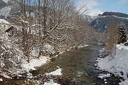
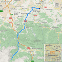
The Steyr's length is approx. 68 km (42 mi). Rising in the Totes Gebirge at Hinterstoder,[2] it flows into the Enns in Steyr. There both rivers form an "Y".[3] The city of Steyr uses this "Y" for marketing purposes.
Tributaries
- Krumme Steyr
- Teichl
- Krumme Steyrling
gollark: I see.
gollark: What? That is Haskell.
gollark: https://hackage.haskell.org/package/lens-4.19.2/docs/Control-Lens-Lens.html#v:-60--60--42--42--126-
gollark: `<**~` - REAL HASKELL OPERATOR
gollark: `<**->` you.
References
- DORIS Atlas (Upper Austria)
- Google (13 February 2020). "Steyr source" (Map). Google Maps. Google. Retrieved 13 February 2020.
- Google (13 February 2020). "Steyr mouth" (Map). Google Maps. Google. Retrieved 13 February 2020.
This article is issued from Wikipedia. The text is licensed under Creative Commons - Attribution - Sharealike. Additional terms may apply for the media files.