Srednja Vas–Poljane
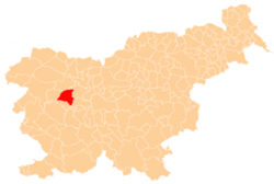
Srednja Vas–Poljane (pronounced [ˈsɾeːdnja ˈʋaːs pɔˈljaːnɛ]; Slovene: Srednja vas-Poljane) is a village on the right bank of the Poljane Sora River, halfway between Poljane and Gorenja Vas in the Municipality of Gorenja Vas–Poljane in the Upper Carniola region of Slovenia.[2]
Srednja Vas–Poljane Srednja Vas (until 1953) | |
|---|---|
 | |
 Srednja Vas–Poljane Location in Slovenia | |
| Coordinates: 46°6′51.36″N 14°9′43.35″E | |
| Country | |
| Traditional region | Upper Carniola |
| Statistical region | Upper Carniola |
| Municipality | Gorenja Vas–Poljane |
| Area | |
| • Total | 1.08 km2 (0.42 sq mi) |
| Elevation | 396.4 m (1,300.5 ft) |
| Population (2002) | |
| • Total | 97 |
| [1] | |
Name
The name of the settlement was changed from Srednja vas to Srednja vas-Poljane in 1953.[3]
Church
The local church, built on a hill above the main settlement, is dedicated to the Holy Cross. It was built in the 1730s in the Baroque style. It used to be particularly well known for its processions during lent. The main altar dates to 1777.[4]
gollark: Bees are just special.
gollark: Besides, we tried that with other stuff and it failed.
gollark: Not *exactly*.
gollark: It really took off around April.
gollark: ?urban apioform
References
- Statistical Office of the Republic of Slovenia
- Gorenja Vas–Poljane municipal site
- Spremembe naselij 1948–95. 1996. Database. Ljubljana: Geografski inštitut ZRC SAZU, DZS.
- Cultural Heritage in the Municipality of Gorenja Vas–Poljane (in Slovene)
External links

- Srednja Vas–Poljane on Geopedia
This article is issued from Wikipedia. The text is licensed under Creative Commons - Attribution - Sharealike. Additional terms may apply for the media files.
