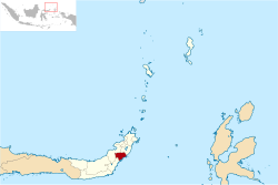
Southeast Minahasa Regency
Southeast Minahasa Regency is a regency in North Sulawesi, Indonesia. Its capital is Ratahan. It covers an area of 710.83 km2, and had a population of 100,443 at the 2010 Census; this had risen to 104,465 at the 2015 Intermediate Census, and the latest official estimate (as at 1 July 2019) is 106,500.[3] It was established as a separate regency from the South Minahasa Regency on 2 January 2007.[4]
Southeast Minahasa Regency Kabupaten Minahasa Tenggara | |
|---|---|
 Seal | |
 Location in North Sulawesi | |
 Southeast Minahasa Regency Location in Indonesia | |
| Coordinates: 1°2′5″N 124°48′36″E | |
| Country | Indonesia |
| Province | North Sulawesi |
| Established | 2 January 2007 |
| Inaugurated | 23 May 2007 |
| Capital | Ratahan |
| Government | |
| • Regent | James Sumendap |
| • Vice Regent | Jesaja Legi |
| Area | |
| • Total | 710.83 km2 (274.45 sq mi) |
| Population (mid 2019)[2] | |
| • Total | 106,500 |
| • Density | 150/km2 (390/sq mi) |
| Time zone | UTC+8 (WITA) |
| Website | mitrakab.go.id |
Administration
The regency is divided into 12 districts (kecamatan), tabulated below with their 2010 Census population.[5]
| Name | Population Census 2010 |
|---|---|
| Ratatotok | 12,117 |
| Pusomaen | 8,519 |
| Belang | 15,224 |
| Ratahan | 12,164 |
| Pasan | 6,594 |
| Ratahan Timur (East Ratahan) | 5,548 |
| Tombatu | 9,008 |
| Tombatu Timur (East Tombatu) | 8,442 |
| Tombatu Utara (North Tombatu) | 7,674 |
| Touluaan | 6,217 |
| Touluaan Selatan (South Touluaan) | 4,079 |
| Silian Raya | 5,157 |
gollark: Ah yes, amazing new revolutionary cryptocurrency #124091275.
gollark: Printers are just really bad, so I don't.
gollark: Well, I *can*, yes, however no.
gollark: I actually realized I can't because Discord is annoying and it doesn't work in browsers.
gollark: These big organizations can also definitely hire plenty of people to do active trading.
References
- North Sulawesi in Figures 2013. Badan Pusat Statistik Sulawesi Utara, 2013, p. 52.
- Badan Pusat Statistik, Jakarta, 2019.
- Badan Pusat Statistik, Jakarta, 2019.
- Undang-Undang Republik Indonesia Nomor 9 Tahun 2007 Archived 2012-01-07 at the Wayback Machine
- Biro Pusat Statistik, Jakarta, 2011.
This article is issued from Wikipedia. The text is licensed under Creative Commons - Attribution - Sharealike. Additional terms may apply for the media files.