South West Khasi Hills district
South West Khasi Hills is an administrative district in the state of Meghalaya in India.
South West Khasi Hills district South West Khasi | |
|---|---|
District of Meghalaya | |
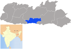 Location of South West Khasi Hills district in Meghalaya | |
| Country | India |
| State | Meghalaya |
| Headquarters | Mawkyrwat |
| Area | |
| • Total | 1,341 km2 (518 sq mi) |
| Population (2011) | |
| • Total | 110,152 |
| • Density | 82/km2 (210/sq mi) |
| Demographics | |
| • Literacy | 76.84 |
| Time zone | UTC+05:30 (IST) |
| Website | southwestkhasihills |
History
The South West Khasi Hills district was carved out of the West Khasi Hills district on 3 August 2012.[1]
Geography
The district headquarters is located at Mawkyrwat. The district occupies an area of 1,341 km². The district is compose all the villages of two Community & Rural Development Blocks viz. Ranikor and Mawkyrwat are Community & Rural Development Block, including 18 (Eighteen) Villages under Warsan Lyngdoh Gram Sevak Circle of Nongstoin in Community & Rural Development Block.
Administrative divisions
South West Khasi Hills district is divided into two blocks
| Name | Headquarters | Population | Location |
| Mawkyrwat | Mawkyrwat | 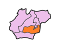 | |
| Ranikor | Ranikor | 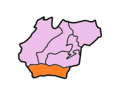 |
gollark: Oh, like the GTech™ Experimental Hyperfractal Officeplex.
gollark: This reminds me vaguely of a web serial I semi-follow: https://www.royalroad.com/fiction/25442/doing-gods-work.
gollark: There are n discussions, where n! - n² + ln(ln(4^n - 7)) = 76.
gollark: Combine the flexibility of JSON with semantic search and graph technology for next generation feature extraction even for large datasets.
gollark: Ah, punycode?
References
- Official circular regarding Mawkyrwat Archived 2013-11-05 at the Wayback Machine
External links
Places adjacent to South West Khasi Hills district | ||||||||||
|---|---|---|---|---|---|---|---|---|---|---|
| ||||||||||
| Topics |
|
|---|---|
| Administration |
|
| Divisions |
|
| Districts | |
| Municipalities | |
| |
This article is issued from Wikipedia. The text is licensed under Creative Commons - Attribution - Sharealike. Additional terms may apply for the media files.