South Wellesley Islands
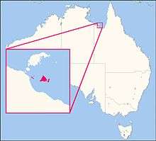
South Wellesley Islands are an island group and locality in the Gulf of Carpentaria within the Shire of Mornington, Queensland, Australia.[2] In the 2016 census, South Wellesley Islands had a population of 0 people.[1]
| South Wellesley Islands Queensland | |
|---|---|
 South Wellesley Islands | |
| Coordinates | 17.0037°S 139.3634°E |
| Population | 0 (2016 census)[1] |
| • Density | 0.000/km2 (0.000/sq mi) |
| Postcode(s) | 4871 |
| Area | 144.2 km2 (55.7 sq mi) |
| Time zone | AEST (UTC+10:00) |
| LGA(s) | Shire of Mornington |
| State electorate(s) | Traeger |
| Federal Division(s) | Kennedy |

Location map of the South Wellesley Islands
Geography
The islands are (west to east):
- Allen Island
- Horseshoe Island
- Albinia Island
- Bentinck Island, where a massacre of indigenous inhabitants, including women and children, occurred in 1918 by colonist 'McKenzie'. [3][4]
- Fowler Island
- Sweers Island
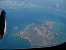
 Southern part of Bentinck Island and Albinia Island
 Bentinck Island with the Australian continent in the background
 the small Fowler Island is located between Seers Island and Bentinck Island
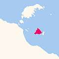
 Location of Bentinck Island
 Southern part of Sweers Island
History
Kayardild (also known as Kaiadilt and Gayadilta) is a language of the Gulf of Carpentaria. The Kayardild language region includes the landscape within the local government boundaries of the Mornington Shire Council.[5]
gollark: I don't think you know what never stopping means, but great.
gollark: It's ideal for high-uptime systems due to the lack of garbage collector - making for consistent performance with no GC spikes - and elegant error handling via algebraic data types.
gollark: Have you considered rewriting it in Rust (programming language)?
gollark: Worrying.
gollark: Even a nonorbital one, perhaps.
References
| Wikimedia Commons has media related to South Wellesley Islands. |
- Australian Bureau of Statistics (27 June 2017). "South Wellesley Islands (SSC)". 2016 Census QuickStats. Retrieved 20 October 2018.

- "South Wellesley Islands - locality in Shire of Mornington (entry 42537)". Queensland Place Names. Queensland Government. Retrieved 13 November 2019.
- Bruce Elder (1998). Blood on the Wattle: Massacres and maltreatment of Aboriginal Australians since 1788. Page 203 - 206: New Holland Publishers. ISBN 1-86436-410-6.CS1 maint: location (link)
- Kelly, Roma; Evans, Nicholas (1985). "The McKenzie massacre on Bentinck Island" (PDF). Aboriginal History. 9 (1). Archived (PDF) from the original on 11 February 2020. Retrieved 13 April 2020.
-

This article is issued from Wikipedia. The text is licensed under Creative Commons - Attribution - Sharealike. Additional terms may apply for the media files.