South Midlands
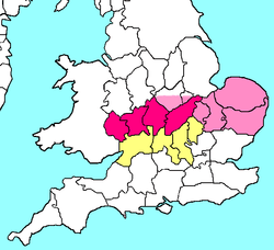
The South Midlands is a notional area of England, (as distinct from the formally designated Regions of England), with no official status nor consensus definition. According to one definition, it is the southern portion of the East Midlands Region (Northamptonshire, south Leicestershire and Rutland) together with the northern portion of the South East England Region (Aylesbury Vale and the Borough of Milton Keynes in north Buckinghamshire) and the western portion of the East of England Region (Bedfordshire). Various organisations also use the name South Midlands to refer to an area that is specific to their own way of dividing up the country. One major usage is as a label for one of the areas identified by HM Government for urban development.
South Midlands | |
|---|---|
 Map of counties in the South Midlands of England. Counties typically included are in pink, counties sometimes included are in light pink, and counties rarely included are in pale yellow. There is no consensus division. | |
| Country | |
| Constituent country | |
| Region | East Midlands West Midlands South East England |
| Counties |
some definitions include southern parts of: some definitions include northern parts of: |
| Time zone | UTC0 (Greenwich Mean Time) |
| • Summer (DST) | UTC+1 (British Summer Time) |
Milton Keynes and South Midlands growth area

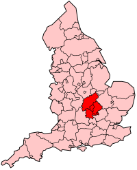
For planning purposes, the Government refers to an area centred on the Borough of Milton Keynes as the Milton Keynes and South Midlands growth area. This area comprises the whole of Bedfordshire, the whole of Northamptonshire, and parts of Buckinghamshire (the borough of Milton Keynes and Aylesbury Vale district) and may be understood to extend into neighbouring Harborough district in south Leicesteshire and Rutland and Rugby. It straddles the boundaries of other regions of England, including portions of the East Midlands, East of England and South East England.[1]
The main settlements are Aylesbury, Milton Keynes, Northampton, Corby, Kettering, Wellingborough, Rushden, Bedford and Luton. A report in 2002 found that: "The most successful economies are those of Milton Keynes and Northampton. Bedford, Corby and the Luton/Dunstable/Houghton Regis area are in need of regeneration."[2]
Other examples
- Amnesty International UK has a South Midlands region that stretches from Newbury, Reading and Bracknell in the south to Bicester and Bedford in the north; and from Wantage in the west, to Stevenage, Letchworth, Welwyn and Hatfield in the east.[3]
- The Council for British Archaeology South Midlands region covers Bedfordshire, Buckinghamshire, Northamptonshire and Oxfordshire.[4]
- Some Joint Industrial Councils defined the South Midlands as Berkshire, Buckinghamshire, Oxfordshire, Hampshire, Wiltshire, the Isle of Wight, and the Channel Islands, most of which would not usually be considered part of the area but sooner as south central England.
- The Pagan Federation South Midlands district covers Bedfordshire, Buckinghamshire, Hertfordshire, Northamptonshire and Oxfordshire.[5]
- The South Midlands League was formed by football teams from Bedfordshire and some adjoining counties.
See also
- Historical and alternative regions of England
- Cambridge - Milton Keynes - Oxford corridor
- North Midlands
- East Midlands
- West Midlands
References
- Milton Keynes South Midlands Archived 1 August 2008 at the Wayback Machine.
- Roger Tym and Partners, Milton Keynes and South Midlands Study: Final Report of the Study, Chapter 8: Conclusions Archived 14 October 2006 at the Wayback Machine.
- Amnesty International Volunteers, Amnesty South Midlands region.
- Council for British Archaeology South Midlands Region.
- The Pagan Federation, South Midlands.