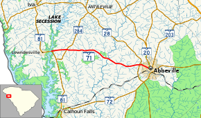
South Carolina Highway 71
South Carolina Highway 71 (SC 71) is a 15-mile-long (24 km) state highway in the northwestern part of the U.S. state of South Carolina. The highway travels in a west-east orientation, however it is designated and signed as a north-south highway. It runs from just east of Lowndesville east to Abbeville, completely within Abbeville County.
| ||||
|---|---|---|---|---|
 | ||||
| Route information | ||||
| Maintained by SCDOT | ||||
| Length | 14.98 mi[1] (24.11 km) | |||
| Major junctions | ||||
| South end | ||||
| North end | ||||
| Location | ||||
| Counties | Abbeville | |||
| Highway system | ||||
| ||||
Route description
SC 71 begins at an intersection with SC 81 just east of Lowndesville. The route heads east, intersecting SC 284. The highway heads east, with a slight southeast jog, before entering Abbeville. It intersects SC 28. Farther into the city is an intersection with the unsigned SC 28 Connector. SC 71's eastern terminus is at an intersection with SC 20 in downtown Abbeville adjacent to the Burt-Stark Mansion.[2]
History
Major intersections
The entire route is in Abbeville County.
| Location | mi[1] | km | Destinations | Notes | |
|---|---|---|---|---|---|
| | 0.00 | 0.00 | |||
| | 2.26 | 3.64 | |||
| Abbeville | 13.38 | 21.53 | |||
| 13.74 | 22.11 | ||||
| 14.98 | 24.11 | ||||
| 1.000 mi = 1.609 km; 1.000 km = 0.621 mi | |||||
See also


References
- "Statewide Highways (shapefile)" (zip). South Carolina Department of Transportation. September 29, 2017. Retrieved December 8, 2017.
- Google (February 3, 2013). "Route of SC 71" (Map). Google Maps. Google. Retrieved February 3, 2013.
External links

- SC 71 South Carolina Hwy Index
