South Carolina Highway 651
South Carolina Highway 651 (SC 651) is a 8.3-mile-long (13.4 km) state highway in the U.S. state of South Carolina. The highway connects Cottageville with rural areas of Colleton County. It is known as Rehoboth Road for its entire length.
| ||||
|---|---|---|---|---|
| Rehoboth Road | ||||
| ||||
| Route information | ||||
| Maintained by SCDOT | ||||
| Length | 8.27 mi[1] (13.31 km) | |||
| Major junctions | ||||
| West end | ||||
| East end | ||||
| Location | ||||
| Counties | Colleton | |||
| Highway system | ||||
| ||||

Route description
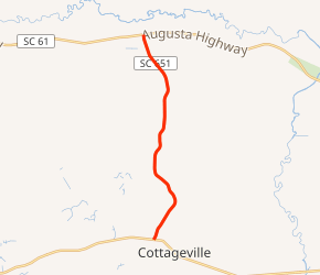
SC 651 begins at an intersection with U.S. Route 17 Alternate (US 17 Alt.; Cottageville Highway) in Cottageville, within Colleton County. It travels to the north-northeast and almost immediately leaves the city limits. The highway curves to the north-northwest and then heads on a fairly northerly direction before crossing over Horse Pen Branch. It curves again to the north-northwest and meets its northern terminus, an intersection with SC 61 (Augusta Highway).[2]
Major intersections
The entire route is in Colleton County.
| Location | mi[1] | km | Destinations | Notes | |
|---|---|---|---|---|---|
| Cottageville | 0.00 | 0.00 | |||
| | 8.27 | 13.31 | |||
| 1.000 mi = 1.609 km; 1.000 km = 0.621 mi | |||||
gollark: Yep, a few came.
gollark: https://www.ibm.com/blogs/research/2019/10/on-quantum-supremacy/Interesting article related to the quantum supremacy thing - apparently IBM ran the same thing on classical computers in a few days, rather than the cited 10000 years.
gollark: It still has a much better e-ink panel than any more DIY-usable ones which consumers seem to be able to get.
gollark: I have a ~2016 basic one lying around somewhere.
gollark: Yep. The tablets are branded Kindle Fire I think.
See also


References
- "Statewide Highways (shapefile)" (zip). South Carolina Department of Transportation. September 29, 2017. Retrieved December 8, 2017.
- Google (May 17, 2016). "South Carolina Highway 651" (Map). Google Maps. Google. Retrieved May 17, 2016.
External links

- SC 651 South Carolina Hwy Index
This article is issued from Wikipedia. The text is licensed under Creative Commons - Attribution - Sharealike. Additional terms may apply for the media files.