South Carolina Highway 58
South Carolina Highway 58 (SC 58) is a 12.5-mile-long (20.1 km) state highway in the U.S. state of South Carolina. The highway connects the Lynchburg area with Turbeville, via Shiloh. Though it is designated an east-west highway, it runs north-south.
| ||||
|---|---|---|---|---|
 | ||||
| Route information | ||||
| Maintained by SCDOT | ||||
| Length | 12.5 mi[1] (20.1 km) | |||
| Major junctions | ||||
| West end | ||||
| East end | ||||
| Location | ||||
| Counties | Lee, Sumter, Clarendon | |||
| Highway system | ||||
| ||||

Route description
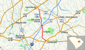
SC 58 begins at an intersection with SC 341 (Lynchburg Highway) just southeast of Lynchburg, within Lee County. It travels on a fairly southern direction, enters Sumter County, and has an intersection with SC 53. The highways travel concurrently to the east and have an interchange with Interstate 95 (I-95) on the northwestern edge of Shiloh. Approximately 500 feet (150 m) later, SC 53 splits off toward the northeast, while SC 58 enters Shiloh proper. Upon leaving the city limits of Shiloh, the highway enters Clarendon County. It curves to the southeast and enters Turbeville. There, it meets its eastern terminus, and intersection with U.S. Route 301 (US 301)/US 378 (Main Street). Here, the roadway continues as Gamble Street.[1]
Major intersections
| County | Location | mi[1] | km | Destinations | Notes |
|---|---|---|---|---|---|
| Lee | | 0.00 | 0.00 | ||
| Sumter | | 5.97 | 9.61 | Western end of SC 53 concurrency | |
| Shiloh | 6.07– 6.26 | 9.77– 10.07 | I-95 exit 141 | ||
| 6.40 | 10.30 | Eastern end of SC 53 concurrency | |||
| Clarendon | Turbeville | 12.52 | 20.15 | ||
1.000 mi = 1.609 km; 1.000 km = 0.621 mi
| |||||
See also


References
- Google (May 6, 2016). "South Carolina Highway 58" (Map). Google Maps. Google. Retrieved May 6, 2016.
External links

- SC 58 South Carolina Hwy Index