South Carolina Highway 340
South Carolina Highway 340 (SC 340) is a 10.9-mile-long (17.5 km) state highway in the U.S. state of South Carolina. The highway connects the Timmonsville area with Darlington.
| ||||
|---|---|---|---|---|
| ||||
| Route information | ||||
| Maintained by SCDOT | ||||
| Length | 10.9 mi[1] (17.5 km) | |||
| Major junctions | ||||
| South end | ||||
| ||||
| North end | ||||
| Location | ||||
| Counties | Darlington | |||
| Highway system | ||||
| ||||

Route description
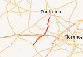
SC 340 begins at an intersection with SC 403 (Oates Highway) north-northwest of Timmonsville, within Darlington County. It travels to the northeast and crosses Middle Swamp and Myrtle Branch before an interchange with Interchange 20 (I-20). It crosses over Jeffries Creek and High Hill Creek before entering the city limits of Darlington. There, it intersects U.S. Route 52 (US 52; Governor Williams Highway). It crosses some railroad tracks before it meets its northern terminus, an intersection with SC 34 (Pearl Street).[1]
Major intersections
The entire route is in Darlington County.
| Location | mi[1] | km | Destinations | Notes | |
|---|---|---|---|---|---|
| | 0.0 | 0.0 | |||
| | 3.8 | 6.1 | I-20 exit 137 | ||
| Darlington | 10.1 | 16.3 | |||
| 10.9 | 17.5 | ||||
| 1.000 mi = 1.609 km; 1.000 km = 0.621 mi | |||||
gollark: Your soul is being bridged to APIONET. Do not resist.
gollark: Idea: no.
gollark: $$e^{i\pi}-1=0$$
gollark: Bow down to my TeX $$skillz$$.
gollark: $$^a_bX^c_d$$
See also


References
- Google (May 14, 2016). "South Carolina Highway 340" (Map). Google Maps. Google. Retrieved May 14, 2016.
External links

- SC 340 South Carolina Hwy Index
This article is issued from Wikipedia. The text is licensed under Creative Commons - Attribution - Sharealike. Additional terms may apply for the media files.