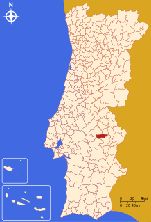
Sousel
Sousel (Portuguese pronunciation: [sowˈzɛl] (![]()
Sousel | |
|---|---|
 Flag .png) Coat of arms | |
 | |
| Coordinates: 38°57′N 7°40′W | |
| Country | |
| Region | Alentejo |
| Intermunic. comm. | Alto Alentejo |
| District | Portalegre |
| Parishes | 4 |
| Government | |
| • President | Manuel Valério (PS) |
| Area | |
| • Total | 279.32 km2 (107.85 sq mi) |
| Population (2011) | |
| • Total | 5,074 |
| • Density | 18/km2 (47/sq mi) |
| Time zone | UTC±00:00 (WET) |
| • Summer (DST) | UTC+01:00 (WEST) |
| Local holiday | Easter Monday date varies |
| Website | http://www.cm-sousel.pt |
The municipality is famous for its olive trees and as a great hunting region.
The Calça e Pina family was the main developer of Sousel in the 18th century. The economy is mainly based on agriculture, but tourism plays a major role in the region's economy as well.
The present Mayor is Manuel Valério, elected by the Socialist Party. The municipal holiday is Easter Monday.
Parishes
Administratively, the municipality is divided into 4 civil parishes (freguesias):[3]
- Cano
- Casa Branca
- Santo Amaro
- Sousel
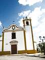 Local church.
 Distinctive Alentejano chimney.
gollark: What's a TQFT and shut up gnobody.
gollark: Hmm, maybe SPUDNET should do pings every 2500ms instead of 10000ms.
gollark: ...
gollark: Yes, it's right in the majority of your cases.
gollark: Go```javascriptconst WebSocket = require("ws")const msgpack = require("@msgpack/msgpack")require("dotenv").config()const ws = new WebSocket(process.argv[2] || "ws://localhost:6086/v4?enc=msgpack")const send = x => ws.send(msgpack.encode(x))ws.on("message", msg => { const data = msgpack.decode(msg) const mtype = data.type if (mtype === "ping") { console.log("ping", data.seq) send({ type: "pong", seq: data.seq }) } else if (mtype === "error") { console.warn(`${data.error} ${data.for}: ${data.detail}`) } else if (mtype === "ok") { console.log(`${data.for}:`, data.result) }})ws.on("open", () => { send({ type: "identify", key: process.env.CLIENT_KEY }) send({ type: "set_channels", channels: [ "ShutdownOS" ] })})```yourself.
References
- Instituto Nacional de Estatística
- Áreas das freguesias, concelhos, distritos e país
- Diário da República. "Law nr. 11-A/2013, page 552 117" (pdf) (in Portuguese). Retrieved 31 July 2014.
External links
| Authority control |
|
|---|
This article is issued from Wikipedia. The text is licensed under Creative Commons - Attribution - Sharealike. Additional terms may apply for the media files.