Somovit Point
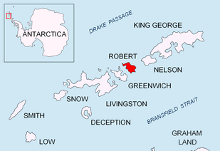
Somovit Point (Bulgarian: нос Сомовит, ‘Nos Somovit’ \'nos 'so-mo-vit\) is a point on the east coast of Robert Island in the South Shetland Islands, Antarctica projecting 500 m into Bransfield Strait between Kruni Cove and Tsepina Cove.

Location of Robert Island in the South Shetland Islands.

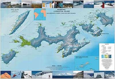
Topographic map of Livingston Island, Greenwich, Robert, Snow and Smith Islands.
It is situated 900 m north-northwest of Batuliya Point and 1.1 km south-southwest of Kitchen Point.
The point is named after the settlement of Somovit in northern Bulgaria.
Location
Somovit Point is located at 62°23′49″S 59°21′04″W. Bulgarian mapping in 2009.
Maps
- L.L. Ivanov. Antarctica: Livingston Island and Greenwich, Robert, Snow and Smith Islands. Scale 1:120000 topographic map. Troyan: Manfred Wörner Foundation, 2009. ISBN 978-954-92032-6-4
gollark: <@160279332454006795> So PotatoASM™ (coming soon)?
gollark: The trouble, although in general I think this is good, is that you can't really have some code run without it being possible for people to inspect it in some way.
gollark: It could be trivially decrypted with the public key which ships with all potatOS builds, which is basically the point.
gollark: Actual "cryptographic obfuscation" would be, I don't know, encrypting stuff with the potatOS signing key™?
gollark: It's MILDLY obfuscated.
References
- Somovit Point. SCAR Composite Gazetteer of Antarctica.
- Bulgarian Antarctic Gazetteer. Antarctic Place-names Commission. (details in Bulgarian, basic data in English)
External links
- Somovit Point. Copernix satellite image
This article includes information from the Antarctic Place-names Commission of Bulgaria which is used with permission.
This article is issued from Wikipedia. The text is licensed under Creative Commons - Attribution - Sharealike. Additional terms may apply for the media files.