Batuliya Point
Batuliya Point (Bulgarian: нос Батулия, ‘Nos Batuliya’ \'nos ba-'tu-li-ya\) is an ice-free tipped point forming the east extremity of Robert Island and the south side of the entrance to Tsepina Cove in the South Shetland Islands, Antarctica.
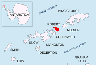
Location of Robert Island in the South Shetland Islands.

Topographic map of Livingston Island, Greenwich, Robert, Snow and Smith Islands.
The point, projecting 550 m into Bransfield Strait, is situated 5.4 km northeast of the southeast extremity of Robert Point, 3 km north-northeast of Sadala Point, and 1.9 km south (and a trifle to the east) of Kitchen Point.
The feature is named after the settlement of Batuliya in western Bulgaria.
Location
Batuliya Point is located at 62°24′16″S 59°20′41″W. Bulgarian mapping in 2009.
Map
- L.L. Ivanov. Antarctica: Livingston Island and Greenwich, Robert, Snow and Smith Islands. Scale 1:120000 topographic map. Troyan: Manfred Wörner Foundation, 2009. ISBN 978-954-92032-6-4
gollark: Anyway, regardless of the actual debate wrt. whether "trap" is a slur, you can *clearly* see that it is not a clear-cut issue in all cases.
gollark: Anything dealing with complex rapidly shifting vaguely political things is *not* simple and commonsensical.
gollark: See, you *can* disagree quite easily.
gollark: Ah, a pneumatic metaencabulation transducer.
gollark: The aggregate bandwidth of sufficiently large carrier pigeon swarms carrying micro-SD cards is actually likely better than any long distance network connection you can feasibly buy.
References
- Batuliya Point. SCAR Composite Gazetteer of Antarctica.
- Bulgarian Antarctic Gazetteer. Antarctic Place-names Commission. (details in Bulgarian, basic data in English)
External links
- Batuliya Point. Copernix satellite image
This article includes information from the Antarctic Place-names Commission of Bulgaria which is used with permission.
This article is issued from Wikipedia. The text is licensed under Creative Commons - Attribution - Sharealike. Additional terms may apply for the media files.