Soem Ngam District
Soem Ngam (Thai: เสริมงาม, pronounced [sɤ̌ːm ŋāːm]; Northern Thai: ![]()
Soem Ngam เสริมงาม | |
|---|---|
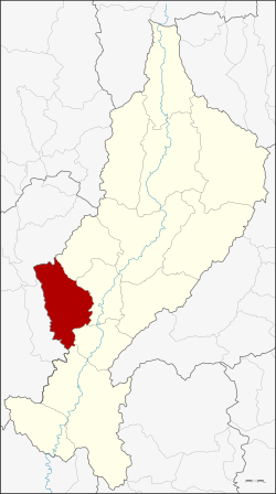 District location in Lampang Province | |
| Coordinates: 18°3′55″N 99°14′50″E | |
| Country | Thailand |
| Province | Lampang |
| Seat | Thung Ngam |
| Area | |
| • Total | 631.727 km2 (243.911 sq mi) |
| Population (2005) | |
| • Total | 32,714 |
| • Density | 51.8/km2 (134/sq mi) |
| Time zone | UTC+7 (ICT) |
| Postal code | 52130 |
| Geocode | 5204 |
Geography
Neighboring districts are (from the northeast clockwise): Hang Chat, Ko Kha, Sop Prap, Thoen of Lampang Province, Thung Hua Chang and Mae Tha of Lamphun Province.
The Khun Tan Range stretches from north to south along the district.
History
Soem Ngam was established as a minor district (king amphoe) on 16 August 1971 by splitting off tambons Thung Ngam, Soem Khwa, and Soem Sai from Ko Ka District.[1] The minor district was upgraded to a full district on 21 August 1975.[2]
Administration
The district is divided into four subdistricts (tambons), which are further subdivided into 42 villages (mubans). Soem Ngam is a subdistrict municipality (thesaban tambon) which covers parts of tambons Thung Ngam, Soem Sai, and Soem Klang. There are a further four tambon administrative organizations (TAO).
| No. | Name[3] | Thai | Villages | Pop.[4] |
|---|---|---|---|---|
| 1. | Thung Ngam | ทุ่งงาม | 11 | 8,211 |
| 2. | Soem Khwa | เสริมขวา | 12 | 7,344 |
| 3. | Soem Sai | เสริมซ้าย | 10 | 8,347 |
| 4. | Soem Klang | เสริมกลาง | 9 | 8,366 |
Resources
- ประกาศกระทรวงมหาดไทย เรื่อง แบ่งท้องที่อำเภอเกาะคา ตั้งเป็นกิ่งอำเภอเสริมงาม จังหวัดลำปาง (PDF). Royal Gazette (in Thai). 88 (90 ง): 2318. August 24, 1971.
- พระราชกฤษฎีกาตั้งอำเภอแวงน้อย อำเภอป่าแดด อำเภอเรณูนคร อำเภอคูเมือง อำเภอคุระบุรี อำเภอแม่ลาน้อย อำเภอเสริมงาม อำเภอไพรบึง และอำเภอหนองโดน พ.ศ. ๒๕๑๘ (PDF). Royal Gazette (in Thai). 92 (166 ก special issue): 1–4. August 21, 1975.
- Thai-English Transcription of Changwat, Amphoe, King Amphoe and Tambon. Bangkok: Kō̜ng Wichākān læ Phǣnngān, Krom Kānpokkhrō̜ng. 2007. ISBN 978-974-7857-04-7.
- "Population statistics 2010". Department of Provincial Administration.