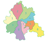
Slobidskyi District
Slobidskyi District (Ukrainian: Слобідський район) is urban district of the city of Kharkiv, Ukraine, named after historical eastern region of Ukraine, Sloboda Ukraine.
Slobidskyi District Слобідський район | |
|---|---|
Urban district | |
| Country | |
| Oblast | Kharkiv Oblast |
| Area | |
| • Total | 24.3 km2 (9.4 sq mi) |
| Population | |
| • Total | 146,850 |
| Time zone | UTC+2 (EET) |
| • Summer (DST) | UTC+3 (EEST) |
|
 |
The district was created in 1940 as Kominternivskyi after the Kharkiv Locomotive Factory of Komintern (today Malyshev Factory. In May 2016 it was renamed to its current name to comply with decommunization laws.[1]
Places
- Chervonyi Promin
- Artema
- Hertzena
- Kachanivka
- Horbani
- Novi Domy
Gallery
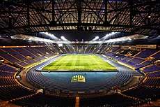 Metalist Stadium

gollark: Hmm, I have no idea what it's actually up to now.
gollark: It unloads the model sometimes and then it takes ages to ununload.
gollark: I have investigated purchasing a GPU, but the only ones available at usable costs are actually quite bad.
gollark: Such as the experimental_qa one.
gollark: I only have access to small amounts of RAM/CPU and no GPU on my server, so unfortunately I can only run small underpowered machine learning cuboids™.
References
- (in Ukrainian) Another 48 streets and 5 districts "decommunized" in Kharkiv, Ukrayinska Pravda (3 February 2015)
(in Russian) Three districts renamed in Kharkiv, SQ (3 February 2015)
(in Ukrainian) In Kharkiv, five metro stations and fifty streets have been communicated, Korrespondent.net, 18 May 2016)
External links
| Districts |
| |
|---|---|---|
| ||
| Raions | |||||
|---|---|---|---|---|---|
| Hromadas | |||||
| Cities |
| ||||
| |||||
This article is issued from Wikipedia. The text is licensed under Creative Commons - Attribution - Sharealike. Additional terms may apply for the media files.