Slims River
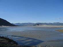
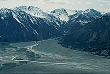
The Slims River (A'ay Chu) was a glacially fed river in the Canadian territory of Yukon.[1] Until 2016,[2] it originated in the Kaskawulsh Glacier, then ran approximately 15 mi (24 km) into the southern terminus of Kluane Lake.[3]


Over the course of a few days in the spring of 2016 the flow of the river was changed.[4] Where the meltwater of the Kaskawulsh Glacier had been draining in two directions now it was all draining into the south-flowing Kaskawulsh river, and further on into the Gulf of Alaska, drastically reducing the size of the Slims.[5] Researchers suggested the change in flow could be due to manmade climate change; this was the first time manmade climate change was implicated in the reorganization of a river.[6]
The Slims River was purportedly named after a pack horse that drowned while attempting to ford the stream during the 1903 Kluane gold rush.[7] It is crossed by the Alaska Highway at Mile 1065 (Kilometer 1704) just south of its confluence with the lake.
References
- "Kaskawulsh Glacier - Canadian Glacier Inventory Project". cgip.wikifoundry.com. Retrieved 2016-01-17.
- "Retreating Yukon glacier makes river disappear". CBC News. Retrieved 2017-02-20.
- "Slims River, Kluane National Park – Map Portfolio – Brodie Elder". bemaps.wordpress.com. Retrieved 2016-01-17.
- Shugar, Daniel H.; Clague, John J.; Best, James L.; Schoof, Christian; Willis, Michael J.; Copland, Luke; Roe, Gerard H. (May 2017). "River piracy and drainage basin reorganization led by climate-driven glacier retreat". Nature Geoscience. 10 (5): 370–375. doi:10.1038/ngeo2932. ISSN 1752-0894.
- "Receding glacier causes immense Canadian river to vanish in four days", Hannah Devlin, The Guardian, 17 April 2017.
- For the first time on record, human-caused climate change has rerouted an entire river
- "The Slims River Bridge, Alaska Highway". explorenorth.com. Retrieved 2016-01-17.