Slavyanka, Kirillovsky District, Vologda Oblast
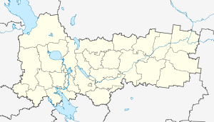
Slavyanka (Russian: Славянка) is a rural locality (a village) in Nikolotorzhskoye Rural Settlement, Kirillovsky District, Vologda Oblast, Russia. The population was 6 as of 2002.[2]
Slavyanka Славянка | |
|---|---|
Village | |
 Slavyanka  Slavyanka | |
| Coordinates: 59°48′N 38°45′E[1] | |
| Country | Russia |
| Region | Vologda Oblast |
| District | Kirillovsky District |
| Time zone | UTC+3:00 |
Geography
The distance to Kirillov is 36 km, to Nikolsky Torzhok is 11 km. Rozhevo is the nearest rural locality.
gollark: "Pop_OS!". It's so stupid a name.
gollark: It is generally desired that help-asking people will provide relevant information, like distro in this case, and also check the wikis or interwebs first.
gollark: https://peter-is-stupid.osmarks.tk/en/Java.html Here's the wiki page for Arch.
gollark: Just check the... Debian? Ubuntu? package list or wiki page.
gollark: But ideally from your distro's package manager.
References
- Карта Кирилловского района Вологодской области
- Данные переписи 2002 года: таблица 2С. М.: Федеральная служба государственной статистики, 2004.
This article is issued from Wikipedia. The text is licensed under Creative Commons - Attribution - Sharealike. Additional terms may apply for the media files.