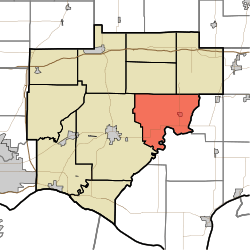
Skelton Township, Warrick County, Indiana
Skelton Township is one of ten townships in Warrick County, Indiana, United States. As of the 2010 census, its population was 1,625 and it contained 635 housing units.[1]
Skelton Township | |
|---|---|
 Location in Warrick County | |
| Coordinates: 38°04′41″N 87°09′07″W | |
| Country | United States |
| State | Indiana |
| County | Warrick |
| Government | |
| • Type | Indiana township |
| Area | |
| • Total | 39.91 sq mi (103.4 km2) |
| • Land | 39.54 sq mi (102.4 km2) |
| • Water | 0.37 sq mi (1.0 km2) 0.93% |
| Elevation | 423 ft (129 m) |
| Population (2010) | |
| • Total | 1,625 |
| • Density | 41.1/sq mi (15.9/km2) |
| ZIP codes | 47523, 47601, 47637 |
| GNIS feature ID | 0453850 |
History
Skelton Township was organized in about 1820.[2] The township was named for Zachariah Skelton, a local judge.[3]
Geography
According to the 2010 census, the township has a total area of 39.91 square miles (103.4 km2), of which 39.54 square miles (102.4 km2) (or 99.07%) is land and 0.37 square miles (0.96 km2) (or 0.93%) is water.[1]
Cities, towns, villages
Unincorporated towns
- Ash Iron Springs at 38.035326°N 87.186669°W
- De Gonia Springs at 38.055604°N 87.185558°W
- Eames at 38.079216°N 87.131668°W
(This list is based on USGS data and may include former settlements.)
Adjacent townships
- Pigeon Township (northeast)
- Jackson Township, Spencer County (east)
- Grass Township, Spencer County (southeast)
- Boon Township (west)
- Owen Township (northwest)
Cemeteries
The township contains these eight cemeteries: Clark, Garrison, Kelley, Mill, Polk, Polk, Reed, Roth and Skelton.
School districts
- Warrick County School Corporation
Political districts
- Indiana's 8th congressional district
- State House District 74
- State Senate District 47
gollark: Accurate orbital prediction is as far as I know basically a solved problem, GPS relies on it.
gollark: True, true.
gollark: You don't really need to *destroy* the incoming rod as much as deflect it a few degrees though, no?
gollark: They radiate tons of heat and you can perfectly predict their orbital path given previous knowledge of it.
gollark: Space things are on the whole not very stealthy anyway.
References
- United States Census Bureau 2007 TIGER/Line Shapefiles
- United States Board on Geographic Names (GNIS)
- IndianaMap
- "Population, Housing Units, Area, and Density: 2010 - County -- County Subdivision and Place -- 2010 Census Summary File 1". United States Census. Archived from the original on 2020-02-12. Retrieved 2013-05-10.
- Barr, Arvil Sylvester (1915). A History of Warrick County, Indiana, Prior to 1820, Including a Sketch of Methodism in the County Down to 1850. Indiana University. p. 17.
- Fortune, William (1881). Warrick and Its Prominent People: A History of Warrick County, Indiana from the Time of Its Organization and Settlement. Courier Company. p. 21.
This article is issued from Wikipedia. The text is licensed under Creative Commons - Attribution - Sharealike. Additional terms may apply for the media files.