Skaftá
The Skaftá is a river in South Iceland. It is primarily glacial in origin and has had its course modified by volcanic activity; as a result of both, it often floods because of glacial melting.
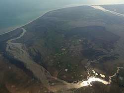
 Aerial view of main branch of the Skaftá where it flows into the Atlantic | |
| Physical characteristics | |
|---|---|
| Mouth | Atlantic Ocean |
• coordinates | 63°39′50″N 17°48′0″W (primary) |
| Length | 115 kilometres (71 mi) |
| Discharge | |
| • average | 122 m3/s (4,300 cu ft/s)[1] |
| Basin features | |
| Landmarks | Kirkjubæjarklaustur |
| Tributaries | |
| • left | Grjótá, Hellisá, Fjaðrá |
| • right | Útfall, Nyðri-Ófærá, Syðri-Ófærá |
Course
The river's primary source is two subglacial "cauldrons" beneath Skaftájökull, part of the Vatnajökull glacier in the interior of Iceland.[2][3] It also receives spring-fed water from Langisjór, a lake a short distance to the west from which a tributary called the Útfall runs into the Skaftá. Other tributaries include the North and South Ófaerá, the Grjótá, and the Hellisá.[4][5]
West of Skaftárdalur, a farm named for the river valley, the Skaftá runs over a lava field in many channels, which recombine into three for the remainder of its course to the Atlantic: the Eldvatn or Ása-Eldvatn combines with the River Kúðafljót; the Ásakvísl or Árkvísla flows under a sand-covered lava field and has been affected by road construction; the third, easternmost branch, which flows near Kirkjubæjarklaustur, retains the name Skaftá[5] but has extremely low water levels when temperatures are lowest.[4] Its total length is approximately 115 kilometres (71 mi).[5]
The river was bridged at Kirkjubæjarklaustur in 1903 and the Ása-Eldvatn was bridged soon after. Efforts to bank and bridge the Ásakvísl have led to undermining of the bridge works and to erosion of land formerly watered by it.[5]
Effects of 1783 eruption
Beginning on June 8, 1783, the multi-year eruption of the volcanic system including Grímsvötn and Þórðarhyrna (sometimes referred to in Icelandic as the Skaftáreldur, Skaftá Fires)[6] filled the river valley with lava, including a gorge thought to have been 200 metres (660 ft) deep,[7] diverting its flow into the multiple shallow channels that now characterize its course. As a result it is subject to jökulhlaups (glacial outburst floods), which occur every one to two years.[2][3][4][5][8][9] The 2015 flood was unusually damaging,[8] the largest since records began.[10]
References
- "Skaftá". Visit Klaustur (in Icelandic). Kirkjubæjarklaustur. Retrieved 2018-12-04.
- Bergur Einarsson; Tómas Jóhannesson; Thorsteinn Thorsteinsson; Eric Gaidos (July 2017). "Subglacial flood path development during a rapidly rising jökulhlaup from the western Skaftá cauldron, Vatnajökull, Iceland". Journal of Glaciology. 63 (240): 670–682. doi:10.1017/jog.2017.33 – via ResearchGate.
- Morgan T. Jones; Iwona M. Gałeczka; Athanasios Gkritzalis-Papadopoulos; Martin R. Palmer; Matthew C. Mowlem; Kristín Vogfjörð; Þorsteinn Jónsson; Sigurður R. Gislason (2015). "Monitoring of jökulhlaups and element fluxes in proglacial Icelandic rivers using osmotic samplers" (PDF). Journal of Volcanology and Geothermal Research. 291: 112–24. doi:10.1016/j.jvolgeores.2014.12.018.
- "Skafta River". Nat.is. Nordic Adventure Travel. Retrieved 2018-12-04.
- "Skaftá". Katla Geopark (in Icelandic). Retrieved 2018-12-04.
- Th. Thordarson; S. Self (May 1993). "The Laki (Skaftár Fires) and Grímsvötn eruptions in 1783–1785". Bulletin of Volcanology (abstract). 55 (4): 233–63. doi:10.1007/BF00624353.
- "Vatnajökull National Park—Lakagigar". Klaustur.is. Kirkjubæjarklaustur. Retrieved 2018-12-04.
- "Jökulhlaups". Lava Centre. Retrieved 2018-12-04.
- Bergur Einarsson (September 2009). "Jökulhlaups in Skaftá: A study of a jökulhlaup from the Western Skaftá cauldron in the Vatnajökull ice cap, Iceland" (PDF). Icelandic Meteorological Office. ISSN 1670-8261.
- Bjarni Pétur Jónsson (2015-10-02). "Mesta Skaftárhlaup síðan mælingar hófust" (in Icelandic). RÚV.
External links
