Siha District
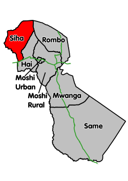
Siha District is one of the seven administrative districts of Kilimanjaro Region in Tanzania.[1] It covers approximately 1,158 square kilometres (447 sq mi).[2] It is bordered to the west by the Arusha Region and to the east by Rombo District and Hai District. The western part of Mount Kilimanjaro is located within the district's boundaries.
Siha District | |
|---|---|
 | |
| Coordinates: 03°11′11″S 37°04′07″E | |
| Country | Tanzania |
| Region | Kilimanjaro Region |
| Population (2012) | |
| • Total | 116,313 |
According to the 2012 Tanzania National Census, the population of Siha District was 116,313.[3]
Administrative subdivisions
As of 2012, Siha District was administratively divided into 12 wards.[3]
Wards
|
|
|
gollark: We can generally react to ongoing present things.
gollark: No. We can infer the past from things other than memory.
gollark: In what way?
gollark: Interesting.
gollark: Morning. We've retroactively altered time by 73 minutes.
References
- Tanzania: Arusha, Tanga, Kilimanjaro Get Three New Districts
- Siha District Profile, Kilimanjaro Region, page 64, accessed 11 November 2014
- "Census 2012". National Bureau of Statistics. Archived from the original on 5 March 2016. Retrieved 20 April 2016.
This article is issued from Wikipedia. The text is licensed under Creative Commons - Attribution - Sharealike. Additional terms may apply for the media files.