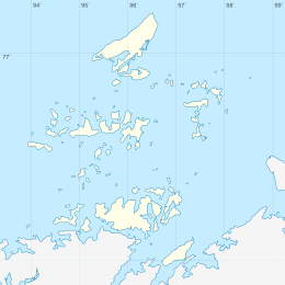
Shpanberg Island
Shpanberg Island (Russian: остров Шпанберга, ostrov Shpanberga) is an island of the Nordenskiöld Archipelago in the Kara Sea, off the coast of Siberia.[1]
| Native name: остров Шпанберга | |
|---|---|
 Shpanberg Island Ostrov Shpanberga Location in the Nordenskjold Archipelago | |
| Geography | |
| Location | Kara Sea |
| Coordinates | 76°41′24″N 96°0′0″E |
| Archipelago | Nordenskiöld Archipelago |
| Length | 5.2 km (3.23 mi) |
| Width | 4.2 km (2.61 mi) |
| Highest elevation | 67 m (220 ft) |
| Administration | |
| Federal subject | Krasnoyarsk Krai |
| Demographics | |
| Population | uninhabited |
Administratively this island belongs to the Krasnoyarsk Krai Federal subject of Russia and is part of the Great Arctic State Nature Reserve, the largest nature reserve of Russia.[2]
Geography
Shpanberg Island is located in the central area of the archipelago on the southern side of the Lenin Strait. The island is 5.2 kilometers (3.2 mi) long and has a maximum width of 4.2 kilometers (2.6 mi). Cape Razvodnoy (мыс Разводной) is the headland at its SE end and Cape Ustalosti (мыс Усталости) at its NE end.[3]
It is part of the Pakhtusov Islands (острова Пахтусова) subgroup of the Nordenskiöld Archipelago. The closest islands are Petersen Island 2.3 kilometers (1.4 mi) to the southeast, Dobrynia Nikitich Island to the SW and Pakhtusov Island 2.3 kilometers (1.4 mi) to the west.[3]
The climate in the archipelago is severe and the sea surrounding the island is covered with fast ice in the winter and often obstructed by pack ice even in the summer.[4]
History
In 1900, the islands of the Nordenskiöld Archipelago were explored by Russian Navy Captain Fyodor Matisen, who named most of them. The survey was done during the first wintering of the Russian polar expedition of 1900–02 on behalf of the Imperial Russian Academy of Sciences led by geologist Baron Eduard Von Toll aboard ship Zarya.
This island was named after Danish-Russian naval lieutenant and Arctic explorer Martin Spangberg, who went with Vitus Bering in both Kamchatka expeditions as second in command.[5]
Further reading
- Albert Hastings Markham. Arctic Exploration, 1895
References
- "Ostrov Shpanberga". Mapcarta. Retrieved 16 August 2016.
- Nature Reserve Archived October 8, 2007, at the Wayback Machine
- Google Earth
- Fast ice conditions near the Nordenskjold Archipelago
- Glynn Barratt. Russia in Pacific Waters, 1715-1825. UBC Press, 1981. ISBN 9780774801171. Pages 35-37.