Shire of Eacham
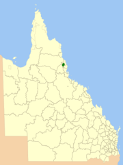
The Shire of Eacham was a local government area of Queensland. It was located on the Atherton Tableland, a plateau forming part of the Great Dividing Range west of the city of Cairns. The shire, administered from the town of Malanda, covered an area of 1,126.4 square kilometres (434.9 sq mi), and existed as a local government entity from 1910 until 2008, when it amalgamated with several other councils in the Tableland area to become the Tablelands Region.
| Shire of Eacham Queensland | |||||||||||||||
|---|---|---|---|---|---|---|---|---|---|---|---|---|---|---|---|
 Location within Queensland | |||||||||||||||
| Population | 6,359 (2006 census)[1] | ||||||||||||||
| • Density | 5.6454/km2 (14.6216/sq mi) | ||||||||||||||
| Established | 1910 | ||||||||||||||
| Area | 1,126.4 km2 (434.9 sq mi) | ||||||||||||||
| Council seat | Malanda | ||||||||||||||
| Region | Far North Queensland | ||||||||||||||
 | |||||||||||||||
Despite its tropical latitude, the high altitude on the tableland allows a dairy industry to operate.
History
On 22 Nov 1910 the area around Lake Eacham was incorporated as the Shire of Eacham, taking in part of each of the Shires of Tinaroo, Johnstone and Cairns.[2][3]
Its first meeting was held at Yungaburra's community hall on 22 February 1911. In April 1912, a site for a shire hall was reserved in Malanda.[4] On 12 April 1913, the shire relocated its offices to Malanda.[5] However, the planned council chambers did not open until 22 Feb 1939.[6]

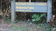
Around 1920, the shire council began an active role in developing the Malanda Falls into the (now heritage-listed) Malanda Falls Swimming Pool and associated infrastructure, initially for local recreation but then increasingly to attract tourists to the area via Cairns.[7]
On 15 March 2008, under the Local Government (Reform Implementation) Act 2007 passed by the Parliament of Queensland on 10 August 2007, the Shire of Eacham merged with the Shires of Atherton, Herberton and Mareeba to form the Tablelands Region.[8]
Towns and localities
The Shire of Eacham included the following settlements:
- Malanda
- Yungaburra
- Butchers Creek
- Glen Allyn
- Jaggan
- Lake Eacham
- Maalan
- Millaa Millaa
- North Johnstone
- Palmerston1
- Peeramon
- Tarzali
- Upper Barron2
1 - shared with Cassowary Coast Region
2 - split with the former Shire of Atherton
Population
| Year | Population |
|---|---|
| 1933 | 4,324 |
| 1947 | 3,740 |
| 1954 | 3,771 |
| 1961 | 3,842 |
| 1966 | 3,598 |
| 1971 | 3,327 |
| 1976 | 3,433 |
| 1981 | 4,137 |
| 1986 | 5,135 |
| 1991 | 5,609 |
| 1996 | 6,074 |
| 2001 | 6,076 |
| 2006 | 6,359 |
Chairmen and mayors
- 1927: R. E. McHugh [9]
- 1988-2000: Philip English
- 2000-2004: Mary Lyle
- 2004-2008: Ray Byrnes
References
- Australian Bureau of Statistics (25 October 2007). "Eacham (S) (Local Government Area)". 2006 Census QuickStats. Retrieved 16 April 2009.
- "A New Shire Created". The Brisbane Courier. National Library of Australia. 23 November 1910. p. 4. Retrieved 26 September 2013.
- "Agency ID 1006, Johnstone Shire Council". Queensland State Archives. Retrieved 26 September 2013.
- "PUBLIC RESERVES". The Brisbane Courier. National Library of Australia. 19 April 1912. p. 3. Retrieved 26 September 2013.
- "Malanda Notes". The Cairns Post. Qld.: National Library of Australia. 10 April 1913. p. 8. Retrieved 26 September 2013.
- "MALANDA AND DISTRICT NOTES". Townsville Daily Bulletin. Qld.: National Library of Australia. 23 February 1939. p. 7. Retrieved 26 September 2013.
- "Malanda Falls Swimming Pool (entry 602733)". Queensland Heritage Register. Queensland Heritage Council. Retrieved 1 August 2014.
- "Agency ID 299, Atherton Shire Council". Queensland State Archives. Retrieved 26 September 2013.
- Pugh, Theophilus Parsons (1927). Pugh's Almanac for 1927. Retrieved 13 June 2014.
External links
- University of Queensland: Queensland Places: Eacham Shire
- Official website at the Wayback Machine (archived February 27, 2008)