Seisdon Hundred
Seisdon is a hundred in the county of Staffordshire, England, located in the south-west of that county. It is named after Seisdon, a locality in the parish of Trysull and Seisdon.

| Seisdon | |
|---|---|
| Former subdivision of England | |
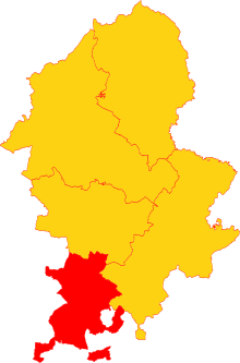
 Seisdon Hundred (red) shown in Staffordshire | |
| History | |
| • Origin | Anglo-Saxon period |
| • Created | 10th century |
| • Abolished | 1894 (obsolete) |
| • Succeeded by | various |
| Status | obsolete area |
| Government | Hundred |
| Subdivisions | |
| • Type | Parishes (see text) |
| • Units | Parishes |
Etymology
The name appears to mean "hill of the Saxons",[1] deriving from the Anglo-Saxon words Seis meaning Saxon and Dun meaning hill. The first element may alternatively be a personal name. A large number of Hundred names refer to hills or mounds. Some of these at least are very conspicuous hills, which afford a commanding view of the countryside for miles around. It seems likely that such sites were chosen as being' remote, and where interference was most easily avoided.[2] The hundred and the hamlet may be named from the hill that was the meeting place of the hundred, instead of the hundred being named after the hamlet.[3]
History
The origin of the hundred dates from the division of his kingdom by King Alfred the Great into counties, hundreds and tithings. From the beginning, Staffordshire was divided into the hundreds of Seisdon, Pirehill, Totmonslow, Cuttleston and Seisdon.[4] Each hundred was formed to support a military unit.
Seisdon Hundred is the smallest in area of the five hundreds of Staffordshire, but it has a relatively high population density and agricultural productivity. It formed the south-western portion of the county, bounded on the west by Shropshire, on the south by Worcestershire, on the east by Offlow Hundred, and on the north by Cuttleston Hundred. The old Forest of Brewood formed the boundary of Seisdon and Cuttleston.[2]

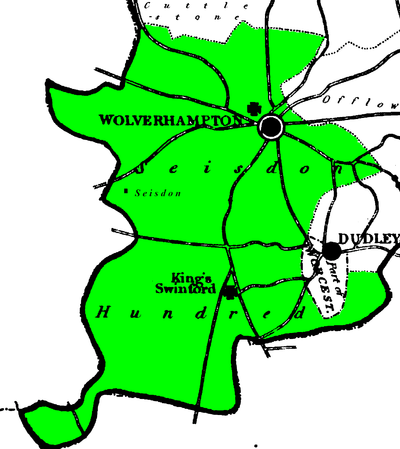
Dark green:South Division Light green:North Division
The Hundred contained Wolverhampton, the largest town of the county, and many populous villages, which were constituted into 15 parishes, part of 5 others and 2 extra-parochial areas. The extensive parish of Wolverhampton contained several townships, only some of which were in Seisdon Hundred.[5]
Seison Hundred was divided into North and South Divisions. each with their own High Constable. This arrangement dates back to 17th century, at least. [6]
One parish, Tettenhall, was divided between the two Divisions of Seisdon. The parish was subdivided into 4 Prebends [7] Two of these, Pendeford and Wrottesley, belonged to Seisdon South and the rest of the parish was in Seisdon North.[8]
The town of Dudley with its suburbs formed a detached portion of the county of Worcestershire. However, Dudley Castle, a ruined castle, with the limestone hill on which it stands, was an extra-parochial area in Seisdon South. It had no inhabitants.[9][10]
Clent (including Broome and Rowley Regis) were seized by the Sheriff of Staffordshire (called Aevic) in 1016, which resulted in them becoming part of Staffordshire [11] Although they were now in Staffordshire, in 19th century Broome, Clent, and Rowley Regis were the only parishes in Staffordshire not included in the Diocese of Lichfield, as they belonged to that of Worcester.[12] All three parishes were included in Seisdon Hundred, but the parishes of Clent and Broome formed a detached part of Staffordshire surrounded by Worcestershire and a detached part of Shropshire. They left Seisdon Hundred in 1844 as they were transferred to Worcestershire.[13]
Seisdon contained following local government units:[8][7] [14] [15] [16]
Seisdon North
| NAME | UNIT | AREA |
|---|---|---|
| Bushbury (part) | Parish | |
| - Bushbury | Township | 3,520 |
| Dudley Castle Hill | Extra Par. | 69 |
| Himley | Parish | 1,200 |
| Kingswinford | Parish | 7,130 |
| Penn | Parish | 3,890 |
| Rowley Regis | Parish | 3,670 |
| Sedgley | Parish | 5,170 |
| Tettenhall (Part) | Parish | 4,119 |
| - Tettenhall with Compton | Prebend | |
| - Pirton with Trescott | Prebend | |
| Wolverhampton (part) | Parish | |
| - Wolverhampton | Township | 3,200 |
| - Bilston | Township | 2,580 |
| TOTAL | 34,548 |
Seisdon South
| NAME | UNIT | AREA |
|---|---|---|
| Bobbington (part) | Parish | 1,880 |
| Broome | Parish | 550 |
| Clent | Parish | 2,520 |
| Codsall | Parish | 2,580 |
| Enville | Parish | 4,930 |
| Kinver (Kinfare) | Parish | 8,790 |
| Old Swinford (part) | Parish | |
| - Amblecote | Hamlet | 570 |
| Patshull | Parish | 1,850 |
| Pattingham (part) | Parish | 2,710 |
| Tettenhall (Part) | Parish | |
| - Pendeford | Prebend | 1868 |
| - Wrottesley | Prebend | 2319 |
| Trysull | Parish | 3,110 |
| Upper Arley | Parish | 5,160 |
| Wombourne | Parish | 4,680 |
| Woodford Grange | Extra Par. | 180 |
| TOTAL | 43,697 |
The Hundred presented a great diversity of soil and scenery. It was rich in coal, ironstone, lime, and freestone, and renowned for its extensive mines and iron works, and for the manufacture of a great variety of articles in iron, steel, and other metals.[5]
Notes
- W.H. Duignan, Notes on Staffordshire Place Names, London: Henry Frowde, 1902
- The English Hundred Names, by Olof Anderson, Lund (Sweden), 1934. Page 145
- The West Midlands in the early Middle Ages, by Margaret Gelling, publ. Leicester University Press, 1992; p142
- A Topographical History of Staffordshire, by William Pitt, pub J. Smith (Newcastle-under-Lyme), 1817; page 13
- History, Gazetteer and Directory of Staffordshire by William White, pub. Sheffield, 1834. Page 163
- Online Catalogue of the Staffordshire and Stoke on Trent Archive Service www.archives.staffordshire.gov.uk/CalmView/Overview.aspx Search:"Seisdon North" retrieved October 2018.
- History, Gazetteer and Directory of Staffordshire by William White, pub. Sheffield, 1834. Page 286
- Census of England and Wales, 1841; County of Stafford, pp.292-293
- History, Gazetteer and Directory of Staffordshire by William White, pub. Sheffield, 1834. Page 336
- Staffordshire Record Office Place guide www.staffordshire.gov.uk/leisure/archives/history/placeguide/SPGDudleyCastleHill.aspx Entry for Dudley Castle Hill Retrieved Nov 2018
- Stourbridge's Western Boundary: A cornerstone of the historical landscape, by K. James, 2017; p.6. Retrieved April 2018.
- History, Gazetteer and Directory of Staffordshire by William White, pub. Sheffield, 1834. Page 29
- Counties (Detached Parts) Act 1844
- Vision of Britain web site www.visionofbritain.org.uk/unit/10277218/cube/AREA_ACRES Article on Dudley Castle Hill. Area recorded under Population in the Units and Statistics section (table view) Retrieved Nov 2018
- Vision of Britain web site www.visionofbritain.org.uk/unit/10297746/cube/AREA_ACRES Article on Woodford Grange. Area recorded under Population in the Units and Statistics section (table view) Retrieved Nov 2018
- The 1841 census included parts of Tettenhall in the Bushbury township figure (Census of England and Wales, 1841, County of Stafford, pp.292-293 - Notes), so the table uses the areas of Tettenhall and Bushbury recorded in the 1891 census - www.visionofbritain.org.uk articles on Tettenhall and Bushbury