Saskatchewan Highway 135
Highway 135 is a highway in the Canadian province of Saskatchewan. It runs from Highway 106 to Sandy Bay. Highway 135 is about 121 km (75 mi) long.[1]
| ||||
|---|---|---|---|---|
 | ||||
| Route information | ||||
| Length | 120.5 km[1] (74.9 mi) | |||
| Major junctions | ||||
| South end | ||||
| North end | Sandy Bay | |||
| Highway system | ||||
Provincial highways in Saskatchewan
| ||||
.svg.png)
Route
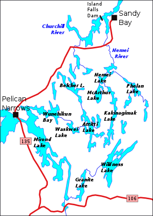
Highway 135 connects with the Jan Lake Access Road near the Jan Lake Provincial Recreation Site, 7 km (4 mi) north of Highway 106. It runs north part Mirond Lake, and crosses the narrows between Mirond and Pelican lakes at Pelican Narrows, and passes through the community of Pelican Narrows within the Peter Ballantyne Cree Nation. From there it runs generally northeast, crosses the Nemei River, and turns north to Sandy Bay on the Churchill River.
gollark: i.e. you can click "something.4" and go to the page for it.
gollark: For the monolith web docs, you should consider making it so that the links work.
gollark: The ones for drones are just blatantly wrong.
gollark: OC's docs *are* quite poor.
gollark: I'm using `warp`, which has nice HTTP combinatory things which are also glacially slow to compile, `sqlx`, which type-checks SQL queries at compile time but is also probably quite slow, and `horrorshow`, a compile-time HTML templating library.
References
- Google (February 17, 2018). "Highway 135 in Saskatchewan" (Map). Google Maps. Google. Retrieved February 17, 2018.
This article is issued from Wikipedia. The text is licensed under Creative Commons - Attribution - Sharealike. Additional terms may apply for the media files.