Sarratt Bottom nature reserve
Sarratt Bottom in Sarratt in Hertfordshire contains a 3.2 hectare biological Site of Special Scientific Interest.
| Site of Special Scientific Interest | |
 | |
| Area of Search | Hertfordshire |
|---|---|
| Grid reference | TQ031989 |
| Interest | Biological |
| Area | 3.2 hectares |
| Notification | 1984 |
| Location map | Magic Map |
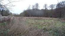
The site is a meadow beside the River Chess. It is an example of damp grassland which has been traditionally managed for grazing. There are also areas of swamp and marsh. The main plants in grassland areas include sweet vernal grass and meadow foxtail, and marsh horsetail and common spike-rush are common in damper areas. The site has hedgehogs and a wide variety of wetland birds and invertebrates.[1]
There is no public access but the site can be viewed from Moor Lane. The local planning authority is Three Rivers District Council.[1][2]
References
- "Sarratt Bottom citation" (PDF). Sites of Special Scientific Interest. Natural England. Retrieved 11 December 2014.
- "Map of Sarratt Bottom". Sites of Special Scientific Interest. Natural England. Retrieved 11 December 2014.
This article is issued from Wikipedia. The text is licensed under Creative Commons - Attribution - Sharealike. Additional terms may apply for the media files.