Santa Rita, Copán
Santa Rita is a municipality in the Honduran department of Copán.
Santa Rita | |
|---|---|
 Santa Rita Location in Honduras | |
| Coordinates: 14°52′N 89°6′W | |
| Country | Honduras |
| Department | Copán |
| Area | |
| • Total | 292 km2 (113 sq mi) |
| Population (2015) | |
| • Total | 30,683 |
| • Density | 110/km2 (270/sq mi) |
History
The municipality of Santa Rita is believed to have been founded in 1700, where it was then known as Aldea Cashapa. However, the area was not recognized as a municipality until 1875.[1] Also it has great people as well living in it.
Villages
A total of 31 villages are in Santa Rita:[2]
- Santa Rita, which is head of the municipality
- Agua Caliente
- Buena Vista
- Campamento
- El Gobiado
- El Jaral
- El Mirador
- El Planón
- El Raizal
- El Rosario
- El Tamarindo
- Gotas de Sangre
- La Canteada
- La Casita
- La Libertad
- La Reforma
- La Unión Otuta
- Las Medias
- Las Mesas
- Los Achiotes
- Los Planes de La Brea
- Los Ranchos
- Minas de Piedras
- Mirasol
- Plan Grande
- Rastrojitos
- Río Amarillo
- Río Blanco
- San Jerónimo
- Tierra Fría No.1
- Tierra Fría No.2
- Vara de Cohete
gollark: I mean, mostly they're designed to separate bots and not-bots, but I suspect Google captchas are also meant to work as weirdly indirect rate limiting, as (when I was doing stuff like adding tens of bots an hour to my discord server) the captchas got progressively harder and then just refused to work entirely.
gollark: Captchas are designed to inflict suffering.
gollark: In general, definitely.
gollark: Anyway, did you solve the vectory thing yet?
gollark: OH NONOT AGAINÅAAAAAAAAAAAAAÆÆÆÆÆÆÆÆ
References
- Fiallos, Carmen. 1989. "Los Municipios de Honduras".
- Instituto Nacional de Estadísticas, Honduras. (Censo 2001)
Capital: Santa Rosa de Copán | ||
| Municipalities | 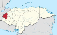 | |
This article is issued from Wikipedia. The text is licensed under Creative Commons - Attribution - Sharealike. Additional terms may apply for the media files.