Santa Fe, Ocotepeque
Santa Fe is a municipality in the Honduran department of Ocotepeque. As of 2015, its population was of 5,006.
Santa Fe | |
|---|---|
Municipality | |
_-_Panoramio.jpg) View of town's center | |
 Santa Fe | |
| Coordinates: 14°31′N 89°14′W | |
| Country | |
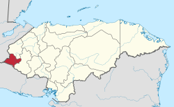
| Department | Ocotepeque |
| Villages | 8 |
| Area | |
| • Total | 64.7 km2 (25.0 sq mi) |
| Elevation | 819 m (2,687 ft) |
| Population (2015) | |
| • Total | 5,006 |
| • Density | 77/km2 (200/sq mi) |
History
%2C_parque_y_templo_-_Panoramio.jpg)
The village was founded in 1860 by people from the nearby town (4.5 km east) of Concepción. It was originally named El Tablón del Guayabo (The Board of Guayabo), due to the abundance of trees of this fruit, then changed its name to the current one.
In 1887 population statistics Santa Fe was ranked as one of the municipalities forming the Ocotepeque Department.[1]
Geography
Located 11 km southeast of the border with Guatemala (at Agua Caliente), and 19 km north of the one with El Salvador (at Citalá), Santa Fe is a hilltown close to the banks of Lempa River. It is 12 km from Ocotepeque, the department capital, and 19 from the Guatemalan town of Esquipulas.
The municipality is divided into 8 parts: the town of Santa Fe and 7 other villages (Aldeas). The villages are Agua Caliente, El Mojanal, La Quesera, Los Encinos,Piedras Bonitas, Piñuelas and Sulnete.[2]
References
- (in Spanish) Carmen Fiallos: Los Municipios de Honduras - 1989
- (in Spanish) Postal code list of Honduras: Santa Fe Municipality, Ocotepeque
External links
![]()