Sandy Ridge, Alabama
Sandy Ridge, sometimes spelled Sandyridge, is an unincorporated community in Lowndes County, Alabama, United States.[1]
Sandy Ridge, Alabama | |
|---|---|
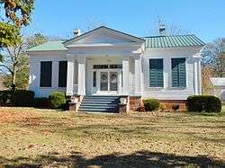 The James Spullock Williamson House, located in Sandy Ridge, is a Greek Revival-style plantation home. | |
 Sandy Ridge  Sandy Ridge | |
| Coordinates: 32.02459°N 86.45191°W | |
| Country | United States |
| State | Alabama |
| County | Lowndes |
| Elevation | 384 ft (117 m) |
| Time zone | UTC-6 (Central (CST)) |
| • Summer (DST) | UTC-5 (CDT) |
| Area code(s) | 334 |
Demographics
| Historical population | |||
|---|---|---|---|
| Census | Pop. | %± | |
| 1880 | 168 | — | |
| U.S. Decennial Census[2] | |||
Sandy Ridge appeared on the 1880 and 1890 U.S. Censuses, but was not separately returned in 1890. It has not appeared on the census rolls since.
Geography
Sandy Ridge is located at 32.02459°N 86.45191°W and has an elevation of 384 feet (117 m).[1]
gollark: Apparently the currently-being-tested single-file version of potatOS contains 5000 lines of bundler output.
gollark: AAAAAAAA WHY IS VSCODE'S INDENTING THING SO USELESS
gollark: Also, it looks like I might be able to ship potatOS as not quite a single file.
gollark: I decided to actually install a Lua plugin for my IDE, and it seems to have dredged up a few minor bugs in potatOS because of undefined globals.
gollark: No, since that *could* just be constantly 20.
References
- U.S. Geological Survey Geographic Names Information System: Sandy Ridge, Alabama
- "U.S. Decennial Census". Census.gov. Retrieved June 6, 2013.
Municipalities and communities of Lowndes County, Alabama, United States | ||
|---|---|---|
| Towns | 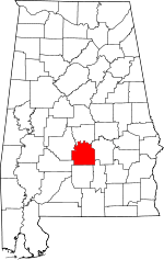 Map of Alabama highlighting Lowndes County | |
| Unincorporated communities | ||
This article is issued from Wikipedia. The text is licensed under Creative Commons - Attribution - Sharealike. Additional terms may apply for the media files.