San Kamphaeng District
San Kamphaeng (Thai: สันกำแพง, pronounced [sǎn kām.pʰɛ̄ːŋ]) is a district (amphoe) of Chiang Mai Province in northern Thailand.
San Kamphaeng สันกำแพง | |
|---|---|
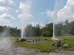 Hot springs of San Kamphaeng | |
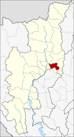 District location in Chiang Mai Province | |
| Coordinates: 18°44′43″N 99°7′13″E | |
| Country | Thailand |
| Province | Chiang Mai |
| Area | |
| • Total | 197.833 km2 (76.384 sq mi) |
| Population (2005) | |
| • Total | 73,721 |
| • Density | 372.6/km2 (965/sq mi) |
| Time zone | UTC+7 (ICT) |
| Postal code | 50130 |
| Geocode | 5013 |
Geography
San Kamphaeng borders the districts (from west clockwise) Saraphi, Mueang Chiang Mai, San Sai, Doi Saket, Mae On of Chiang Mai Province and Ban Thi of Lamphun Province.
History
The district dates back to khwaeng Mae Om, which was established in 1902. In 1923 the district was renamed San Kamphaeng.
Administration
The district is divided into 10 sub-districts (tambons), which are further subdivided into 100 villages (mubans). There are two townships (thesaban tambons). San Kamphaeng covers parts of tambons San Kamphaeng and Chae Chang, and the entire tambon Sai Mun. Ton Pao covers the entire tambon of Ton Pao. There are a further eight tambon administrative organizations (TAO).
| No. | Name | Thai name | Villages | Pop. | |
|---|---|---|---|---|---|
| 1. | San Kamphaeng | สันกำแพง | 14 | 13,686 | |
| 2. | Sai Mun | ทรายมูล | 7 | 4,230 | |
| 3. | Rong Wua Daeng | ร้องวัวแดง | 11 | 5,718 | |
| 4. | Buak Khang | บวกค้าง | 13 | 7,851 | |
| 5. | Chae Chang | แช่ช้าง | 9 | 7,585 | |
| 6. | On Tai | ออนใต้ | 11 | 5,371 | |
| 10. | Mae Pu Kha | แม่ปูคา | 9 | 5,969 | |
| 11. | Huai Sai | ห้วยทราย | 8 | 6,217 | |
| 12. | Ton Pao | ต้นเปา | 10 | 11,006 | |
| 13. | San Klang | สันกลาง | 8 | 6,088 |
Numbers 7–9,14,15 are tambons which now belong to Mae On District.