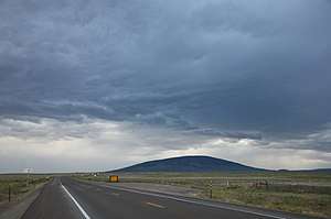
San Antonio Mountain (New Mexico)
San Antonio Mountain is a free-standing volcanic peak in Rio Arriba County, New Mexico. With an elevation of 10,908 feet, San Antonio Mountain is the highest peak within the Taos Plateau volcanic field, the largest volcanic field within the Rio Grande Rift valley.
| San Antonio Mountain | |
|---|---|
 San Antonio Mountain, New Mexico, as seen from the Colorado side of the NM-CO state line on U.S. Route 285 | |
| Highest point | |
| Elevation | 10,912 ft (3,326 m) NAVD 88[1] |
| Prominence | 2,108 ft (643 m) [2] |
| Coordinates | 36°51′34″N 106°01′07″W |
| Geography | |
 San Antonio Mountain | |
| Location | Rio Arriba County, New Mexico, U.S. |
| Topo map | USGS San Antonio Mountain N. Mex. |
| Geology | |
| Mountain type | Shield volcano |
| Volcanic arc | Taos Plateau volcanic field |
The mountain lies just outside a northwest boundary of the Rio Grande del Norte National Monument. It lies within the Carson National Forest and is administered by the U.S. Forest Service rather than the Bureau of Land Management.
It is called "Bear Mountain" by Tewa-speaking peoples in the Rio Grande valley, and is known as the mountain of the north in their cosmology.[3]
Geography
San Antonio Mountain is one of several volcanic peaks within the 7000 square kilometer Taos Plateau volcanic field, a region of tectonic uplift within the Rio Grande rift valley. Other nearby peaks include Ute Mountain (10,082 feet), Cerro de la Olla (9,475 feet), Cerro del Aire (9,023 feet), and Cerro Montoso (8,655 feet). San Antonio Mountain is both the highest peak in the region and possesses the greatest relief, but it is shorter than the highest peaks in the surrounding ranges: Grouse Mesa (11,403 feet) in the Tusas Mountains to the west, and Wheeler Peak (13,161 feet) in the Sangre de Cristo Mountains to the east. However, because it stands alone, San Antonio Mountain is a distinctive feature that can be seen from as far as 60 or more miles away in southern Colorado and northern New Mexico.[3]
San Antonio Mountain has a base diameter of five miles, and rises dramatically from the surrounding sagebrush plains of the lower San Luis Valley.[3]
Flora and fauna
The mountain features Gambel oak and ponderosa pine, with Douglas fir, Engelmann spruce, and quaking aspens at higher elevations.[3][4]
San Antonio Mountain is an important winter habitat for migrating herds of elk, and hosts one of the largest populations of elk in New Mexico, estimated at 7,000 individuals.[5] The mountain and its surroundings also provide habitat for pronghorn, golden eagle, hawks, bears, mountain lions, mule deer and white-tailed jackrabbits among other smaller mammals. In the fall, the Stuart Meadows wetlands on the nearby Rio San Antonio provide a stopover for migrating Sandhill cranes, mallards, American wigeon, Northern pintail, common yellowthroat, and sora.[4]
References
| Wikimedia Commons has media related to San Antonio Mountain (Rio Arriba County, New Mexico). |
| Wikimedia Commons has media related to Taos Plateau Volcanic Field. |
- "San Antone". NGS data sheet. U.S. National Geodetic Survey. Retrieved February 14, 2014.
- "San Antonio Mountain, New Mexico". Peakbagger.com. Retrieved February 14, 2014.
- Julyan, Robert Hixson (2006). The Mountains of New Mexico. UNM Press. p. 368. ISBN 0826335160.
- "San Antonio Mountain - Watchable Wildlife Site #14" (PDF). Wildlife Restoration. Archived from the original (PDF) on October 29, 2013. Retrieved October 26, 2013.
- Smallidge, Samuel T.; et al. (March 2003). "Demographics, temporal and spatial dynamics, and resource conflict evaluation of elk wintering near San Antonio Mountain in North Central New Mexico" (PDF). Federal Aid in Wildlife Restoration Project W-136-R. New Mexico Game & Fish and Wildlife Restoration. Archived from the original (PDF) on July 23, 2013. Retrieved October 26, 2013.
External links
- "San Antonio Mountain". SummitPost.org.