Salemsborg, Kansas
Salemsborg is an unincorporated community in southern Saline County, Kansas, United States.[1] It lies at 38°41′44.31″N 97°41′02.66″W, or about 10 miles south-southwest of Salina at the intersection of Burma Road and Salemsborg Road.[1]
Salemsborg, Kansas | |
|---|---|
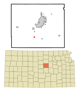 Location within Saline County and Kansas | |
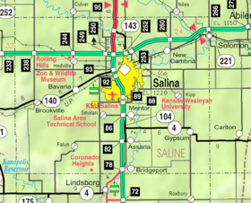 KDOT map of Saline County (legend) | |
| Coordinates: 38°41′44.31″N 97°41′02.66″W | |
| Country | United States |
| State | Kansas |
| County | Saline |
| Government | |
| • Type | Unincorporated community |
| Elevation | 1,328 ft (405 m) |
| Time zone | UTC-6 (Central Standard Time) |
| • Summer (DST) | UTC-5 (Central Daylight Time) |
| ZIP code | 67456 |
| Area code | 785 |
Demographics
As a part of Saline County, Salemsborg is a part of the Salina micropolitan area.[2]
Education
The community is served by Smoky Valley USD 400 public school district.
gollark: ???
gollark: I know the *bid* is lowercased.
gollark: Maybe.
gollark: Ah, logos, planning to bid on the obelisk?
gollark: But the SYSTEM lowercases it, no?
References
- Saline County Planning Department. "Web mapping application". Saline County planning maps. Archived from the original on February 13, 2010. Retrieved 2010-04-06.
- Nussle, Jim (2008-11-20). "Micropolitan Statistical Areas" (PDF). List 1-9. Office of Management and Budget, Executive Office of the President. p. 97. Retrieved 2010-04-02.
Further reading
External links
- Saline County Map, KDOT
Municipalities and communities of Saline County, Kansas, United States | ||
|---|---|---|
| Cities | 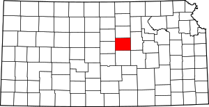 Map of Kansas highlighting Saline County | |
| CDPs | ||
| Unincorporated communities | ||
| Townships |
| |
| Footnotes | ‡This populated place also has portions in an adjacent county or counties | |
This article is issued from Wikipedia. The text is licensed under Creative Commons - Attribution - Sharealike. Additional terms may apply for the media files.