Salem Township, Muskingum County, Ohio
Salem Township is one of the twenty-five townships of Muskingum County, Ohio, United States. The 2000 census found 830 people in the township, 703 of whom lived in the unincorporated portions of the township.[3]
Salem Township, Muskingum County, Ohio | |
|---|---|
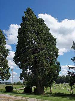 Ohio's largest known Atlantic White Cedar stands in front of New Hope Lutheran Church | |
 Location of Salem Township in Muskingum County | |
| Coordinates: 40°3′36″N 81°52′33″W | |
| Country | United States |
| State | Ohio |
| County | Muskingum |
| Area | |
| • Total | 25.2 sq mi (65.3 km2) |
| • Land | 25.2 sq mi (65.3 km2) |
| • Water | 0.0 sq mi (0.0 km2) |
| Elevation | 856 ft (261 m) |
| Population (2000) | |
| • Total | 830 |
| • Density | 32.9/sq mi (12.7/km2) |
| Time zone | UTC-5 (Eastern (EST)) |
| • Summer (DST) | UTC-4 (EDT) |
| FIPS code | 39-69932[2] |
| GNIS feature ID | 1086732[1] |
Geography
Located in the northeastern part of the county, it borders the following townships:
- Adams Township - north
- Monroe Township - northeast corner
- Highland Township - east
- Union Township - southeast corner
- Perry Township - south
- Washington Township - southwest
- Madison Township - northwest
The village of Adamsville is located in northwestern Salem Township.
Name and history
Salem Township was named after Salem, Massachusetts, the native home of a large share of the early settlers.[4] It is one of fourteen Salem Townships statewide.[5]
By the 1830s, Salem Township had a gristmill, a saw mill and two churches.[6]
Government
The township is governed by a three-member board of trustees, who are elected in November of odd-numbered years to a four-year term beginning on the following January 1. Two are elected in the year after the presidential election and one is elected in the year before it. There is also an elected township fiscal officer,[7] who serves a four-year term beginning on April 1 of the year after the election, which is held in November of the year before the presidential election. Vacancies in the fiscal officership or on the board of trustees are filled by the remaining trustees.
The trustees elected in 2005 are Max Fox and Larry Wisecarver,[8] and the trustee and clerk elected in 2003 are Samuel Mitchell and S. Dean Reed.[9]
References
- "US Board on Geographic Names". United States Geological Survey. 2007-10-25. Retrieved 2008-01-31.
- "U.S. Census website". United States Census Bureau. Retrieved 2008-01-31.
- Muskingum County, Ohio — Population by Places Estimates Ohio State University, 2007. Accessed 15 May 2007.
- Everhart, F.J. (1882). 1794. History of Muskingum County, Ohio, with illustrations and biographical sketches of prominent men and pioneers. F.J. Everhart & Co. p. 464.
- "Detailed map of Ohio" (PDF). United States Census Bureau. 2000. Retrieved 2007-02-16.
- Kilbourn, John (1833). The Ohio Gazetteer, or, a Topographical Dictionary. Scott and Wright. pp. 402. Retrieved 12 December 2013.
- §503.24, §505.01, and §507.01 of the Ohio Revised Code. Accessed 4/30/2009.
- Statement of Votes Cast, Muskingum County Board of Elections, p. 41. Created 2005-11-21, accessed 2007-10-14.
- OFFICIAL CUMULATIVE REPORT, Muskingum County Board of Elections, 2003-11-18. Accessed 2007-10-14.
External links
Municipalities and communities of Muskingum County, Ohio, United States | ||
|---|---|---|
| City | 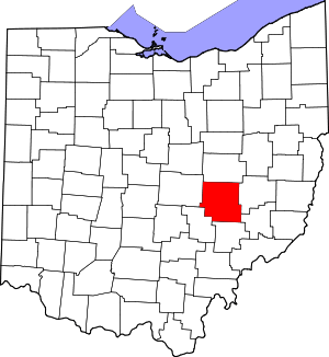 Map of Ohio highlighting Muskingum County | |
| Villages | ||
| Townships | ||
| CDPs | ||
| Unincorporated communities |
| |
| Former communities |
| |
| Footnotes | ‡This populated place also has portions in an adjacent county or counties | |