Saint George's Channel (Papua New Guinea)
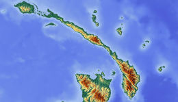
Saint George's Channel in the Bismarck Archipelago, lies between New Ireland and New Britain. It is named by analogy with St George's Channel between Great Britain and Ireland.
| Saint George's Channel | |
|---|---|
 Saint George's Channel | |
| Coordinates | 4°31′39″S 152°33′38″E |
| Type | strait |
History
During World War II Saint George's Channel was used by the Imperial Japanese Navy connecting Rabaul to the open sea and for ships bound for the Solomon Islands. Allied missions against Japanese forces at Cape St. George and St. George's Channel were conducted at December 31, 1942 - October 26, 1944.[1][2]
gollark: No, Google can access and monetize basically your entire browsing data.
gollark: But... why? You could just... be spied on a lot less... for reasonably little hassle.
gollark: But they will also spy on you more than firefox does.
gollark: To spite people who want to change language for no apparent reason, I'm replacing all variable names in my code with different capitalizations of "master", "slave", and "literal beehive".
gollark: ... but you can just use other free stuff which is not horrible?
See also
References
- Allied missions against Cape St. George and St. Georges Channel Pacific Wrecks Inc.
- Saint Georges Channel New Ireland Province Papua New Guinea (PNG) Pacific Wrecks Inc.
This article is issued from Wikipedia. The text is licensed under Creative Commons - Attribution - Sharealike. Additional terms may apply for the media files.