Saint-Léonard Parish, New Brunswick
Saint-Léonard is a civil parish[lower-alpha 1] in Madawaska County, New Brunswick, Canada.[2]
Saint-Léonard St. Leonard | |
|---|---|
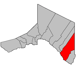 Location within Madawaska County, New Brunswick. | |
| Coordinates: 47.235°N 67.8°W | |
| Country | |
| Province | |
| County | Madawaska |
| Established | 1850 |
| Area | |
| • Land | 345.39 km2 (133.36 sq mi) |
| Population (2016)[1] | |
| • Total | 975 |
| • Density | 2.8/km2 (7/sq mi) |
| • Change 2011-2016 | |
| • Dwellings | 422 |
| Time zone | UTC-4 (AST) |
| • Summer (DST) | UTC-3 (ADT) |
For governance purposes it is divided between the town of Saint-Léonard[3] and the local service district of the parish of Saint-Léonard,[4] which further includes the special service areas of Poitier and Saint-Léonard-Parent.
Delineation
Saint-Léonard Parish is defined in the Territorial Division Act[5] as being bounded:
- Bounded easterly by the Victoria County line; southwesterly by the St. John River and northwesterly by the following described line:
- Beginning at a point in the International Boundary line where the same is intersected by the western prolongation of the south limit of lot No. 99, granted to Andrew Michaud; thence in an easterly direction along said prolongation and said limit of said lot, the eastern prolongation of same and the south limit of lot No. 281, granted to Rosomo Violette, and its eastern prolongation to a point in the eastern bank or shore of the Grand River;[lower-alpha 2] thence in a northerly direction along said bank or shore of said river to a point where the same is intersected by the west limit of lot No. 218, granted to Wm. Byram; thence in a southerly direction along said limit of said lot to the southwest angle of the same; thence in an easterly and southerly direction following the south limit of Tier One, south of the aforesaid Grand River, to the southeast angle of lot No. 272, granted to A. Dube; thence in an easterly direction along the division line between the Second Tract and the Fourth Tract West, granted to the New Brunswick Railway Company, and the eastern prolongation of same to a point in the aforesaid Victoria County line, including the Islands in front, but excepting therefrom the Parish of Saint-André.
Communities
Parish population total does not include incorporated municipalities (in bold):
|
|
Demographics
Population
|
LanguageMother tongue (2016)[1]
|
gollark: LyricLy doesn't know what "less" means, see.
gollark: No.
gollark: OH APIO, I restarted Firefox and now several YouTube videos are speaking to me.
gollark: osmarkscalculator™ wouldn't be wrong like that.
gollark: That's just 9^9.
See also
Notes
- Civil parishes served a variety of government functions until 1966, when the new Municipalities Act stripped them of their responsibilities; they continue to provide convenient boundaries for government uses, especially electoral districts and local service districts. Statistics Canada uses civil parishes as census subdivisions for all parts of the province that are not within municipalities and similar entities.
- Now officially Grande Rivière.[6]
References
- "Census Profile, 2016 Census: Saint-Léonard, Parish [Census subdivision], New Brunswick". Statistics Canada. Retrieved September 23, 2019.
- "Chapter T-3 Territorial Division Act". Government of New Brunswick. Retrieved 22 July 2020.
- "New Brunswick Regulation 85-6 under the Municipalities Act (O.C. 85-45)". Government of New Brunswick. Retrieved 19 July 2020.
- "New Brunswick Regulation 84-168 under the Municipalities Act (O.C. 84-582)". Government of New Brunswick. Retrieved 19 July 2020.
- "Territorial Division Act (R.S.N.B. 1973, c. T-3)". Government of New Brunswick website. Retrieved 26 August 2016.
- "Grand River (Grande Rivière)". Canadian Geographical Names. Natural Resources Canada. Retrieved 26 August 2016.
- Statistics Canada: 1996, 2001, 2006 census
- 2011 Statistics Canada Census Profile: Saint-Léonard Parish, New Brunswick
Places adjacent to Saint-Léonard Parish, New Brunswick | |
|---|---|
| Subdivisions |
|
|---|---|
| Cities | |
| Counties | |
| |
This article is issued from Wikipedia. The text is licensed under Creative Commons - Attribution - Sharealike. Additional terms may apply for the media files.