Saint-Jacques Parish, New Brunswick
Saint-Jacques is a civil parish[lower-alpha 1] in Madawaska County, New Brunswick, Canada.[2]
Saint-Jacques St. Jacques | |
|---|---|
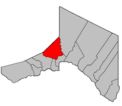 Location within Madawaska County. Map is missing northeastern portion of Parish. | |
| Coordinates: 47.43°N 68.385°W | |
| Country | |
| Province | |
| County | Madawaska |
| Established | 1877 |
| Area | |
| • Land | 299.49 km2 (115.63 sq mi) |
| Population (2016)[1] | |
| • Total | 1,596 |
| • Density | 5.3/km2 (14/sq mi) |
| • Change 2006-2011 | |
| • Dwellings | 748 |
| Time zone | UTC-4 (AST) |
| • Summer (DST) | UTC-3 (ADT) |
The parish consists of two discontiguous portions separated by Saint-Joseph Parish. For governance purposes the southwestern portion is divided between the city of Edmundston[3] and the local service district of the parish of Saint-Jacques;[4] the northeastern portion is part of the LSD.
Delineation
Saint-Jacques Parish is defined in the Territorial Division Act[5] as being bounded:
- Beginning on the west side of the Madawaska River at the southeastern angle of lot No. 16 granted to Charles Hughes thence in a westerly direction along the southern limit of said lot No. 16 to the west limit of lots fronting on the west side of the Madawaska River thence in a southerly direction along the said west limit to the north limit of lots in the Second Tier north of the St. John River thence westerly along said northern limit to a point where it is intersected by the northeast limit of Tier Six Riceville [Settlement] thence in a northwesterly direction along said limit of said Tier Six to the northeast angle of lot No. 51 in said Tier Six thence southwesterly along the northern limit of said lot No. 51 to the southwest angle of lot No. 58 thence northwesterly along the southwest limit of said lot No. 58 to the eastern limit of Tier Three of Rang-des-Morneault[lower-alpha 2] thence northerly along said limit to the northeast angle of lot No. 17 in Tier Three granted to Jos. P. Nadeau thence westerly along the north limit of said limit No. 17 to the western limit of Tier Three thence northerly along said limit to the New Brunswick-Quebec boundary line thence in an easterly direction along said boundary line to the east limit of lots in Sweeney Settlement thence in a southerly direction and following the various courses of the east limit of Sweeney Settlement to the southeast angle of lot No. 2 in Sweeney Settlement, the front part of which is granted to Marcel Grandmaison thence northwesterly along the southwest limit of said lot No. 2 to the southwest angle of said lot No. 2 thence southerly along the east limit of Tier Three east of the Madawaska River to the northeast angle of lot No. 213 in Tier Three granted to Peter Plourde thence westerly along the northern limit of said lot No. 213 to the east limit of Tier Two thence southerly following the various courses of the east limit of Tier Two to the northeast angle of lot No. 214 in Tier Two granted to P. Couturier thence westerly along the northern limit of said lot No. 214 to the east limit of lots fronting on the east side of the Madawaska River thence southerly along said limit to the southeastern angle of lot No. 16 granted to Cyprien Michaud thence westerly along the southern limit of said lot No. 16 and its prolongation to the western shore of the Madawaska River thence following said shore in a northerly direction upstream to the place of beginning.
- Also:- Including all that portion of the County of Madawaska lying between the Green River and the Lake Branch of Green River.[lower-alpha 3]
Communities
Parish population total does not include incorporated municipalities (in bold) and communities within their respective boundaries (in italics).
|
|
Demographics
Population
| Canada census – Saint-Jacques Parish, New Brunswick community profile | |||
|---|---|---|---|
| 2016 | 2011 | 2006 | |
| Population: | 1,596 (-0.2% from 2011) | 1,599 (-0.5% from 2006) | 1,607 (-6.3% from 2001) |
| Land area: | 299.49 km2 (115.63 sq mi) | 299.80 km2 (115.75 sq mi) | 298.82 km2 (115.38 sq mi) |
| Population density: | 5.3/km2 (14/sq mi) | 5.4/km2 (14/sq mi) | |
| Median age: | 51.2 (M: 52.0, F: 50.2) | 46.5 (M: 47.3, F: 45.7) | 43.8 (M: 44.1, F: 43.4) |
| Total private dwellings: | 748 | 710 | 750 |
| Median household income: | $57,003 | $65,389 | $46,347 |
| References: 2016[8] 2011[9] 2006[10] earlier[11] | |||
|
|
| |||||||||||||||||||||||||||
| [12][1] | |||||||||||||||||||||||||||||
Language
| Canada Census Mother Tongue - Saint-Jacques Parish, New Brunswick[12][1] | ||||||||||||||||||
|---|---|---|---|---|---|---|---|---|---|---|---|---|---|---|---|---|---|---|
| Census | Total | French |
English |
French & English |
Other | |||||||||||||
| Year | Responses | Count | Trend | Pop % | Count | Trend | Pop % | Count | Trend | Pop % | Count | Trend | Pop % | |||||
2016 |
1,600 |
1,525 | 95.3% | 60 | 3.8% | 5 | 0.3% | 10 | 0.6% | |||||||||
2011 |
1,600 |
1,535 | 95.94% | 50 | 3.12% | 10 | 0.62% | 5 | 0.31% | |||||||||
2006 |
1,605 |
1,530 | 95.33% | 40 | 2.49% | 35 | 2.18% | 0 | 0.00% | |||||||||
2001 |
1,720 |
1,650 | 95.93% | 50 | 2.91% | 10 | 0.58% | 10 | 0.58% | |||||||||
1996 |
1,715 |
1,660 | n/a | 96.79% | 25 | n/a | 1.46% | 30 | n/a | 1.75% | 0 | n/a | 0.00% | |||||
gollark: Well, as knowledge tends to infinity, confidence never actually converges.
gollark: It does, kind of.
gollark: No units will be provided.
gollark: I made this very useful mathematical model.
gollark: How does it work? I'm not sure I would trust a random bot to unilaterally ban people.
See also
Notes
- Civil parishes served a variety of government functions until 1966, when the new Municipalities Act stripped them of their responsibilities; they continue to provide convenient boundaries for government uses, especially electoral districts and local service districts. Statistics Canada uses civil parishes as census subdivisions for all parts of the province that are not within municipalities and similar entities.
- Actually Mitchell Settlement[6]
- Now officially simply Lake Branch.[7]
References
- "Census Profile, 2016 Census: Saint-Jacques, Parish [Census subdivision], New Brunswick". Statistics Canada. Retrieved September 23, 2019.
- "Chapter T-3 Territorial Division Act". Government of New Brunswick. Retrieved 22 July 2020.
- "New Brunswick Regulation 85-6 under the Municipalities Act (O.C. 85-45)". Government of New Brunswick. Retrieved 19 July 2020.
- "New Brunswick Regulation 84-168 under the Municipalities Act (O.C. 84-582)". Government of New Brunswick. Retrieved 19 July 2020.
- "Territorial Division Act (R.S.N.B. 1973, c. T-3)". Government of New Brunswick website. Retrieved 26 August 2016.
- "Crown Grant Reference Map Viewer". GeoNB. Government of New Brunswick. Retrieved 26 August 2016.
- "Lake Branch". Canadian Geographical Names. Natural Resources Canada. Retrieved 26 August 2016.
- "2016 Community Profiles". 2016 Canadian Census. Statistics Canada. February 21, 2017. Retrieved 2019-09-23.
- "2011 Community Profiles". 2011 Canadian Census. Statistics Canada. July 5, 2013. Retrieved 2014-03-22.
- "2006 Community Profiles". 2006 Canadian Census. Statistics Canada. March 30, 2011. Retrieved 2014-03-22.
- "2001 Community Profiles". 2001 Canadian Census. Statistics Canada. February 17, 2012.
- Statistics Canada: 1996, 2001, 2006, 2011 census
Places adjacent to Saint-Jacques Parish, New Brunswick | ||||||||||
|---|---|---|---|---|---|---|---|---|---|---|
| ||||||||||
| Subdivisions |
|
|---|---|
| Cities | |
| Counties | |
| |
This article is issued from Wikipedia. The text is licensed under Creative Commons - Attribution - Sharealike. Additional terms may apply for the media files.