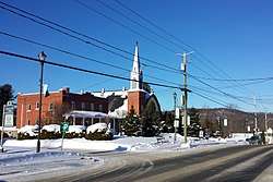
Saint-Hippolyte, Quebec
Saint-Hippolyte is a municipality within La Rivière-du-Nord Regional County Municipality in the Laurentides region of Quebec, Canada, in the Laurentian mountains about 45 km north of Montreal. The name comes from Saint Hippolytus.
Saint-Hippolyte | |
|---|---|
Municipality | |
 | |
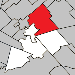 Location within La Rivière-du-Nord RCM | |
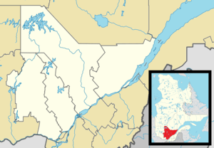 Saint-Hippolyte Location in central Quebec | |
| Coordinates: 45°56′N 74°01′W[1] | |
| Country | |
| Province | |
| Region | Laurentides |
| RCM | La Rivière-du-Nord |
| Constituted | July 1, 1855 |
| Government | |
| • Mayor | Bruno Laroche |
| • Federal riding | Rivière-du-Nord |
| • Prov. riding | Rousseau |
| Area | |
| • Total | 132.60 km2 (51.20 sq mi) |
| • Land | 120.65 km2 (46.58 sq mi) |
| Population (2011)[3] | |
| • Total | 8,083 |
| • Density | 67.0/km2 (174/sq mi) |
| • Pop 2006-2011 | |
| Time zone | UTC−5 (EST) |
| • Summer (DST) | UTC−4 (EDT) |
| Postal code(s) | J8A 1A1 |
| Area code(s) | 450 and 579 |
| Highways | |
| Website | saint-hippolyte |
Part of the town was formerly known as Abercrombie-Est.
Police services are provided by the Régie intermunicipale de police de la Rivière-du-Nord, which also serves Piedmont, Prévost and some other communities in the Laurentians.
Demographics
Population trend:[4]
- Population in 2011: 8083 (2006 to 2011 population change: 12.0%)
- Population in 2006: 7219
- Population in 2001: 6039
- Population in 1996: 5672
- Population in 1991: 4697
Private dwellings occupied by usual residents: 3,558 (total dwellings: 4,784)
Mother tongue:
- French as first language: 92.6%
- English as first language: 4.7%
- English and French as first language: 1%
- Other as first language: 1.7%
Education
The Commission scolaire de la Rivière-du-Nord operates French-language public schools.[5]
- École primaire des Hauteurs
- The primary school École des Hautbois in Saint-Colomban, Jean-Moreau in Sainte-Sophie and Sacré-Coeur in Saint-Jérôme serve sections
- École secondaire Cap-Jeunesse and École secondaire des Hauts-Sommets in Saint-Jérôme
Sir Wilfrid Laurier School Board operates English-language public schools. Schools serving the town:
- Morin Heights Elementary School in Morin-Heights serves a portion of the town[6]
- Laurentia Elementary School in Saint-Jérôme serves a portion of the town[7]
- Ste-Adèle Elementary School in Saint-Adèle serves a portion of the town[8]
- Laurentian Regional High School in Lachute[9]
References
- Reference number 56730 of the Commission de toponymie du Québec (in French)
- Geographic code 75045 in the official Répertoire des municipalités (in French)
- "(Code 2475045) Census Profile". 2011 census. Statistics Canada. 2012.
- Statistics Canada: 1996, 2001, 2006, 2011 census
- "Trouver une école ou un centre." Commission scolaire de la Rivière-du-Nord. Retrieved on September 24, 2017. For attendance boundary information, click "Par bassin d'école"
- "MORIN HEIGHTS ELEMENTARY ZONE." Sir Wilfrid Laurier School Board. Retrieved on September 16, 2017.
- "LAURENTIA ELEMENTARY ZONE." Sir Wilfrid Laurier School Board. Retrieved on September 4, 2017.
- "maps zone/171 - WEB SAINTE ADELE.pdf SAINTE ADÈLE ELEMENTARY ZONE." Sir Wilfrid Laurier School Board. Retrieved on September 16, 2017.
- "LAURENTIAN REGIONAL HS ZONE." Sir Wilfrid Laurier School Board. Retrieved on September 4, 2017.
External links

Places adjacent to Saint-Hippolyte, Quebec | ||||||||||
|---|---|---|---|---|---|---|---|---|---|---|
| ||||||||||
| Towns | |
|---|---|
| Municipalities | |
| |
| Authority control |
|
|---|