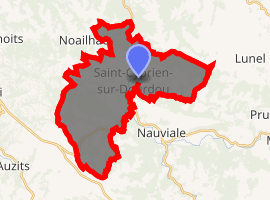
Saint-Cyprien-sur-Dourdou
Saint-Cyprien-sur-Dourdou (Occitan: Sent Cebrian) is a former commune in the Aveyron department in southern France. On 1 January 2016, it was merged into the new commune of Conques-en-Rouergue.[2]
Saint-Cyprien-sur-Dourdou | |
|---|---|
Part of Conques-en-Rouergue | |
Former abbatial residence | |
 Coat of arms | |
Location of Saint-Cyprien-sur-Dourdou 
| |
 Saint-Cyprien-sur-Dourdou  Saint-Cyprien-sur-Dourdou | |
| Coordinates: 44°32′53″N 2°24′46″E | |
| Country | France |
| Region | Occitanie |
| Department | Aveyron |
| Arrondissement | Rodez |
| Canton | Lot et Dourdou |
| Commune | Conques-en-Rouergue |
| Area 1 | 30.23 km2 (11.67 sq mi) |
| Population (2017)[1] | 894 |
| • Density | 30/km2 (77/sq mi) |
| Time zone | UTC+01:00 (CET) |
| • Summer (DST) | UTC+02:00 (CEST) |
| Postal code | 12320 |
| Elevation | 229–645 m (751–2,116 ft) (avg. 248 m or 814 ft) |
| 1 French Land Register data, which excludes lakes, ponds, glaciers > 1 km2 (0.386 sq mi or 247 acres) and river estuaries. | |
Population
| Year | Pop. | ±% |
|---|---|---|
| 1962 | 830 | — |
| 1968 | 925 | +11.4% |
| 1975 | 863 | −6.7% |
| 1982 | 849 | −1.6% |
| 1990 | 778 | −8.4% |
| 1999 | 766 | −1.5% |
| 2008 | 813 | +6.1% |
gollark: ``` A language based on the idea of communism. There would be only one great editor (a wiki or similar) and all programmers would write only one big program that does everything. There would be only one datatype that fits everything, so everything belongs to one single class. Functional programming is clearly based on the idea of communism. It elevates functions (things that do the work) to first class citizens, and it is a utopian endeavor aimed at abolishing all states. It is seen as inefficient and unpopular, but always has die-hard defenders, mostly in academia. Besides, ML stands for Marxism-Leninism. Coincidence? I think not. It should be called Soviet Script and the one big program can be called the Universal Soviet Script Repository or USSR for short. And they put all the packages together in one place (Hackage). It already exists and is called 'Web'. It already exists and is called 'Emacs'. Emacs is the one great editor, and the one big program (Emacs can do almost anything). The language is Emacs Lisp, which is functional, and almost everything is a list (the one great datatype/class). Unfortunately```
gollark: It's pronounced Piephoon, by the way.
gollark: Owwww, my eyes.
gollark: I personally use LineageOS, microG and the Yalp play store thing.
gollark: By "don't use google" I mean the search engine; I guess Android is also google, but if you use an AOSP ROM and use alternatives for google apps/services, it's fine.
See also
This article is issued from Wikipedia. The text is licensed under Creative Commons - Attribution - Sharealike. Additional terms may apply for the media files.