Saint-Ciergues
Saint-Ciergues is a municipality in the French department of Haute-Marne (Grand Est region) and has 163 inhabitants (2004). The site is part of the district of Langres .
Saint-Ciergues | |
|---|---|
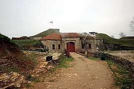 The Pointe de Diamant fort in Saint-Ciergues | |
Location of Saint-Ciergues 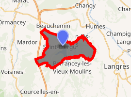
| |
 Saint-Ciergues  Saint-Ciergues | |
| Coordinates: 47°53′06″N 5°15′19″E | |
| Country | France |
| Region | Grand Est |
| Department | Haute-Marne |
| Arrondissement | Langres |
| Canton | Langres |
| Government | |
| • Mayor | Daniel Séguin |
| Area 1 | 12.45 km2 (4.81 sq mi) |
| Population (2017-01-01)[1] | 189 |
| • Density | 15/km2 (39/sq mi) |
| Time zone | UTC+01:00 (CET) |
| • Summer (DST) | UTC+02:00 (CEST) |
| INSEE/Postal code | 52447 /52200 |
| Elevation | 329–457 m (1,079–1,499 ft) (avg. 400 m or 1,300 ft) |
| 1 French Land Register data, which excludes lakes, ponds, glaciers > 1 km2 (0.386 sq mi or 247 acres) and river estuaries. | |
Geography
The area of Saint-Ciergues is 12,7 km², the population density is 12.8 inhabitants per km². The lowest level is 329 meters and the highest level is 457 meters The map below shows the location of Saint-Ciergues with the main infrastructure and neighboring municipalities.
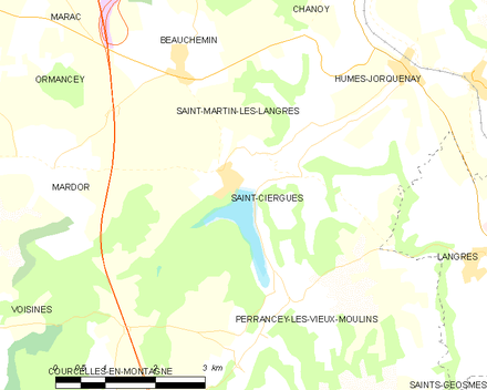
Map commune FR insee code 52447
Demography
The figure below shows the progress of the population (source: INSEE counts).

Population - Municipality code 52447
gollark: No, ridiculous.
gollark: Yes, the African Union is an excellent example which all countries should aspire to match.
gollark: It uses a weirdly inconsistent hybrid.
gollark: It does mostly.
gollark: Here in the UK™ we still use miles for distance, and sometimes inches/feet for height.
References
- "Populations légales 2017". INSEE. Retrieved 6 January 2020.
| Wikimedia Commons has media related to Saint-Ciergues. |
| Authority control |
|
|---|
This article is issued from Wikipedia. The text is licensed under Creative Commons - Attribution - Sharealike. Additional terms may apply for the media files.