Sørvágur Municipality
Sørvágur Municipality (Sørvágs kommuna) is the westernmost municipality in the Faroe Islands.
Sørvágur Municipality Sørvágs kommuna | |
|---|---|
Municipality | |
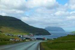 Sørvágur, view on Mykines | |
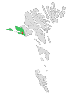 Location of Sørvágur within Sørvágur municipality in the Faroe Islands | |
| Coordinates: 62°06′N 7°24′W | |
| State | |
| Constituent country | |
| Island | Vágar |
| Municipality | Sørvágur |
| Population (1 January 2020) | |
| • Total | 1,236 |
| Time zone | GMT |
| • Summer (DST) | UTC+1 (WEST) |
| Postal code | FO 380 |
| Website | http://www.sorvag.fo/ |
It consists of the villages of Sørvágur, Bøur, Gásadalur and Mykines. Originally the municipality only included the village of Sørvágur, but on January 2005 the municipality of Sørvágur agreed to merge with the smaller municipalities of Bøur/Gásadal and Mykines.
The new municipality had a population of 1,236 in 2020.[1]
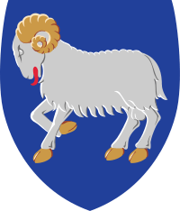
Logo
.JPG)
Village idyll in Bøur.
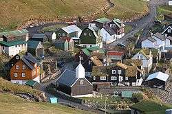
Bøur as seen from above, Oct 2005
The logo of the municipality is two white birds on a white/blue background with an orange sundisk. The two birds are made in the image of the letters S and K which are the initials for Sørvágs Kommuna.
gollark: It seems like they're just interested in knowing magic physics words, or something, and not their actual meaning?
gollark: I tried to explain some basic statistics to them a while ago, and they mangled it horribly.
gollark: I'm not sure if they actually ever notice me insulting them, though.
gollark: They do manage to get less frustrated with nemysmerp1 or whatever it is than me.
gollark: I see.
References
- Fólkatal Archived 2013-09-21 at the Wayback Machine - Municipality website
External links
- Sorvag.fo Webpage for the municipality of Sørvágur.
Municipalities of the Faroe Islands | ||
|---|---|---|
 | ||
This article is issued from Wikipedia. The text is licensed under Creative Commons - Attribution - Sharealike. Additional terms may apply for the media files.