Kahl (river)
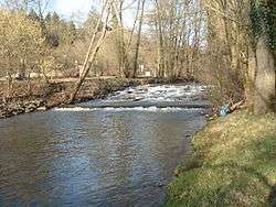
The Kahl is a river in the northern Spessart in Bavaria and Hesse, Germany. It is a right tributary of the Main and is 35.6 km (22.1 mi) long.[1] The name Kahl comes from the Old High German word kaldaha, which means cool and clear. The Kahl rises from two sources left and right of the road at the foot of the Spessart hills, near Kleinkahl. These springs produce 50–60 litres per second. The Kahl flows into the river Main in Kahl am Main. The mouth is near the old Kahl Nuclear Power Plant. The largest tributaries are Westerbach, Sommerkahl, Reichenbach and Geiselbach.
| Kahl | |
|---|---|
 Kahl in Alzenau | |
| Location | |
| Country | Germany |
| State | Bavaria, Hesse |
| Reference no. | DE: 24772 |
| Physical characteristics | |
| Source | |
| • location | near Kleinkahl |
| • coordinates | 50°07′17″N 9°18′59″E |
| Mouth | |
• location | in Kahl into the Main |
• coordinates | 50°03′59″N 8°59′29″E |
| Length | 35.6 km (22.1 mi) [1] |
| Basin size | 206 km2 (80 sq mi) [1] |
| Discharge | |
| • average | 1.89 m³/s[2] |
| Basin features | |
| Progression | Main→ Rhine→ North Sea |
Tributaries
Tributaries from source to mouth:
|
Left
|
Right
|
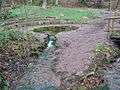 The right spring of the Kahl
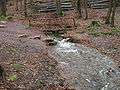 The left spring
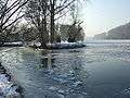 Mouth in the river Main
gollark: I mean "accelerationism" like that political thing where you help the opposing movement because it'll magically destroy itself or something.
gollark: It would no longer be possible for humans to cut many of them down.
gollark: Also deforestation. There are so many upsides.
gollark: Which would also fix flooding.
gollark: Also, rising sea levels. This could be eliminated as an issue by breaking all the various feedback loops enough that the oceans boil.
References
- Complete table of the Bavarian Waterbody Register by the Bavarian State Office for the Environment (xls, 10.3 MB)
- Hochwassernachrichtendienst Bayern
| Wikimedia Commons has media related to Kahl. |
This article is issued from Wikipedia. The text is licensed under Creative Commons - Attribution - Sharealike. Additional terms may apply for the media files.