Geiselbach (river)
The Geiselbach is a right tributary of the Kahl in the northern Spessart in Bavaria and Hesse, Germany. It is 5,2 km (3,2 mi) long and begins at the confluence of multiple headstreams in Geiselbach. The largest tributary is the Omersbach. It discharges near the Teufelsmühle ("Devil's Mill"). The Geiselbach flows through the Teufelsgrund ("Devil's Valley") to Hüttelngesäß and forms the border between Hesse and Bavaria. Near the village Brücken it empties into the Kahl.
| Geiselbach | |
|---|---|
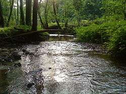 The Geiselbach in Teufelsgrund | |
| Location | |
| Country | Germany |
| Location | Bavaria, Hesse |
| Reference no. | DE: 247728 |
| Physical characteristics | |
| Source | |
| • location | near Geiselbach |
| • coordinates | 50°07′27″N 9°12′29″E |
| Mouth | |
• location | near Niedersteinbach in the Kahl |
• coordinates | 50°05′32″N 9°08′31″E |
| Length | 6.5 km (4.0 mi) [1] |
| Basin features | |
| Progression | Kahl→ Main→ Rhine→ North Sea |
| Tributaries | |
| • left | Omersbach |
Together with Westerbach, Sommerkahl and Reichenbach, the Geiselbach is one of the largest tributaries of the Kahl.
Tributaries
- Omersbach (left)
gollark: This is apioform.
gollark: So it works in about 30ms - perfectly okay - *without* the ts_headline, but takes about 30 seconds *with* it.
gollark: It gives a snippet of the page text basically.
gollark: It looks like it somehow incurs a "bitmap heap scan" and "nested loop" but I have no clue why.
gollark: I don't understand why including `ts_headline(pageText, query, 'MaxFragments=3,MaxWords=60')` suddenly makes Postgres decide to operate about 100 times slower on this.
References
- Complete table of the Bavarian Waterbody Register by the Bavarian State Office for the Environment (xls, 10.3 MB)
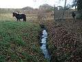 a headstream of the Geiselbach
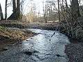 near Hüttelngesäß
 the mouth in the Kahl
| Wikimedia Commons has media related to Geiselbach (River). |
This article is issued from Wikipedia. The text is licensed under Creative Commons - Attribution - Sharealike. Additional terms may apply for the media files.